|
Coseley, like the surrounding area,
was covered by dense woodland, interrupted only by local
rivers and streams. It would seem that the area was
largely unoccupied until Saxon times, even the Romans
left few traces there.
The area was initially colonised by
the Anglo-Saxons. They came from France, the
Netherlands, Germany and Denmark. Angles and Saxons
first reached our shores during the Roman occupation and
were mentioned by the Roman historian Ammianus
Marcellinus, who considered them as barbarians along with
the Picts and Scots. He mentions raids in 365. The
mid-fifth century Gallic Chronicle mentions a large raid
in 410, after the Roman army had departed.
At this time there were frequent
raids by continental pirates and many towns employed
mercenary soldiers for protection. These soldiers were
Angles and Saxons from northern Germany who brought
their families with them and were given farmland as
payment for their services. Soon the mercenaries
realised that they were stronger than their employers
and so began to take over the running of many areas. The
Anglo-Saxons slowly colonised England, moving northwards
and westwards, pushing the native Celts into Cornwall,
Wales and Scotland.
Anglo-Saxon England was a turbulent
country with a number of competing kingdoms, always
under threat from European invaders. As the Anglo-Saxons
slowly colonised the country, seven kingdoms were
established which later became known as the “Heptarchy”.
They were: East Anglia, Essex, Kent, Mercia,
Northumbria, Sussex and Wessex. Mercia, Northumbria and
Wessex were in a continuous state of war.
South Staffordshire was a part of
Mercia, which was derived from the old English word “Mierce”,
meaning People of the Boundaries. It was founded in the
6th century. The kingdom developed from settlements in
the upper Trent valley and was colonised by a band of
Angles called the Iclingas. Slowly the area was
populated and the kingdoms of the Saxon and Angles in
the midlands amalgamated to form the kingdom of Mercia,
with its capital at Tamworth.
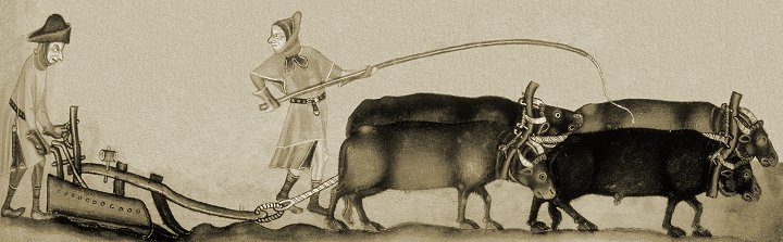
Settlers moving into the area would
have found or made clearings in the woodland to build
their houses, keep their cattle and grow their crops. It
seems likely that early colonisation of the Black
Country began in the 7th or 8th century when a tribe
called the Anglian Mercens came from the north.
Initially they followed the Trent Valley, and began
spreading along the valleys of the Tame and its
tributaries. They were known as the Tomsaetan (dwellers
by the Tame). The River Tame flows through Wednesbury,
Tipton and Oldbury. They would have been the first
people to settle here, and no doubt made use of the
ready-made clearings, and the excellent water supply
from the local brooks. One of them, Cockle Brook, flows
off the Dudley and Sedgley hills into Wall Brook, and
finally into the River Tame.
Evidence for early settlements can
be found in many of the names of local towns, which are
Anglo-Saxon in origin. The old English word “leah” means
a woodland clearing and can be found in the following
local place names:
Bentley, Brierley Hill, Coseley (or
Colseleye), Cradley Heath, Dudley, Graiseley, Himley,
Moseley, Oxley, Sedgley, Wordsley and Wrottesley.
Sedgley means Secg's clearing,
Dudley means Dudda's clearing, and part of Darlaston is
known as The Leys. The old English word “halh” meaning a
pocket of land appears in the following names:
Blakenhall, Ettingshall, Tettenhall
and Willenhall, which means the meadowland of Willan.
The old English word “tun” means a
settlement and this is found in Bilston, Darlaston and
Wolverhampton. Wednesbury is recorded as Wadnesberie.
The first part of the name (Wadnes) refers to Woden, the
Saxon's god of war, and the second part (berie) is
derived from the old English byrig, meaning a burgh, or
burh, which is a fort. So Wednesbury means Woden's fort.
The old name for Tipton was 'Tibbington'. The middle
part of the name 'ing' simply means plural, so the name
refers to the settlement of the Tibbs, the surname of
the settling family, or their leader.
In 913, Stafford became the capital
of Mercia, after it had been fortified by Queen
Aethelfaed. Within a few years, the Shire of Stafford
was formed. It was divided into 5 'Hundreds', each
consisting of an area roughly supporting 100 households.
They were Cuttlestone, Offlow, Pirehill, Seisdon and
Totmonslow. Part of Coseley was in Ettingshall, with the
remainder in Sedgley. Ettingshall in its original form
extended from Parkfield to Woodsetton. Both were in the
Hundred of Seisdon, which would have been headed by a
hundred-man or hundred elder, who oversaw justice and
administration in the area, organised the supply of
soldiers, and led them into battle. Hundreds were
usually named after the place where meetings where held,
to discuss local issues, and where trials took place.
Coseley would have had a small
farming community that existed for several hundred
years. Around one sixth of the land would probably have
been cleared for farming, all that was necessary to
support such a small population.
The first recorded reference to any
part of what is now Coseley and the immediate
surrounding area, can be found in Lady Wulfrun’s Charter
in 994 which describes the boundaries of the land that
she endowed to Wolverhampton Church (Now St. Peter’s,
then St. Mary’s). Lady Wulfrun was possibly the sister
of King Edgar, and the mother of Wulfric Spot. It
includes a reference to Hinde Brook and Ettingshall.
Lady Wulfrun is supposed to have had a healing spring
near to Spring Vale in Ettingshall and there is a
tradition that another of her healing wells, Hollywell,
was at Hurst Hill.
Prior to the Norman invasion, both
Ettingshall and Sedgley were held by Leofric, Earl of
Mercia and his wife, Lady Godiva. They had a son, Algar
(Elf-spear), who was appointed Earl of East Anglia by
King Edward in 1051, after Leofric had helped to
suppress Earl Godwin’s revolt. Algar owned a lot of land
in Mercia and became Earl of Mercia on his father’s
death in 1057.
Domesday
After the Norman invasion in 1066,
William the Conqueror made it known that he personally
owned all of the land in the country. He appointed
around 200 barons as tenants in chief, and allowed them
to hold large areas of land, in exchange for the payment
of taxes, and the provision of soldiers when necessary.
The system, later known as feudalism, was the key to the
Norman's success.
The Normans were descended from
Vikings who had settled in Normandy, married into the
local population and adopted the French culture. After
the invasion, they quickly gained control of the southern
part of the county, but were met with hostility in the
north and east.
The Normans held on to the Saxon
'Hundreds', but carved-up the land into areas called
manors, each controlled by a Baron, or Norman Lord. They
had to take an oath of loyalty to the King, carry-out
any required duties, and pay taxes for their land.
Staffordshire came under the
control of a Norman baron called Ansculf de Picquigny,
who fortified the hill above Dudley. Some time after
1070 he built the first Dudley Castle, a motte and
bailey structure, consisting of an earthen mound topped
with a timber tower, surrounded by a defensive timber
palisade. He was known as the Sheriff of Buckingham, and
lived until the mid 1080s. After his death, his son,
William Fitz Ansculf, inherited his title and lands. He
was in control of more than 80 manors, scattered across
several counties and like his father, was based at
Dudley Castle. Very little remains of the 11th century
buildings, most of what we see today dates from the 14th
century.
William Fitzansculph’s holdings
included Amblecote, Aston, Birmingham, Bushbury,
Chasepool, Dudley, Edgbaston, Enville, Erdington,
Essington, Ettingshall, Great Barr, Handsworth, Himley,
Moseley, Newport Pagnell, Orton, Oxley, Pendeford, Penn,
Perry Barr, Sedgley, Seisdon, Trysull, Witton, and
Wombourne.
William’s tenant at Ettingshall was
Robert de Thurstan, who was also tenant at some of
William’s other holdings, including Bushbury, Moseley,
Oxley and Upper Penn.
In 1085 the Danes threatened to
invade, and so King William decided to commission a
detailed audit of the country, to extract all of the
taxes owed to him, and to ensure that the maximum number
of soldiers were available to deal with the expected
invasion. The survey was so detailed that an entry in
the Anglo Saxon Chronicle states that 'not even an ox,
or a cow, or a swine was not set down in his writ.' It
seemed so invasive, and all-seeing, that it felt as
though judgement day had come. As a result it became
known as the Domesday Book.
All 400 pages of the book, record
in extraordinary detail, how the Normans organised their
new kingdom. Everything on the estate would have been
owned and controlled by the manor, or the clergy,
including property, money, religion, and even marriage.
There were labour services to do on the land, and heavy
rents to be paid. The majority of food produced, and
animals reared were consumed by the lord of the manor
and his household. Many families lived off a simple
vegetable soup called pottage. The average life
expectancy was just 25.
At the time, Coseley, with its tiny
community, was of little interest and so is not directly
listed in the Domesday Book, which does however include
Sedgley and Ettingshall. A team of investigators would
arrive in an area where they would meet with the
landowner, the local priest and a group of older
villagers.
Each manor would include several
villages whose inhabitants were called peasants. There
were several classes of peasant. The highest was a
freeman who was free to pursue a trade. The other
classes were owned as part of the land and were not free
to move around. They were villeins, bordars, cottars and
serfs. A villein offered agricultural services to his
lord, a bordar was a smallholder who farmed on the edge
of a settlement, a cottar was a cottager and a serf was
an agricultural labourer. In return the lord of the
manor was supposed to protect and help them. The other
major landowner was the church. Bishops and abbots
could be tenants in chief or lesser tenants.
The information gathered for
Ettingshall was as follows: 9 villagers, 3 cottagers and
2 ploughs. The 12 households meant a population of
around 60. There were 4 ploughlands, 2 lord's plough
teams, 2 men's plough teams, 5 acres of meadow and an
area of woodland occupying 3 by 3 furlongs,
approximately 3,642 square metres. The annual rent was 1
pound 10 shillings.
The information gathered for
Sedgley was in two entries, as follows: The larger
settlement had 45 villagers, 2 cottagers, 3 slaves, one
priest and 12 ploughs. The smaller settlement had 9
villagers with 2 ploughs and 2 acres of meadow. The
population would have been around 300. The annual rent
was 20 shillings.
The Domesday Book was not completed
until after King William’s death on 9th September 1087.
Today it is the most important source of information
about village life in the Middle Ages.
In Saxon and Norman times there
would have been just a few single storey timber framed
buildings, possibly clad with timber, or even wattle and
daub, and covered with a thatched, or turfed roof. There
would have been a hearth for a fire, with the smoke
escaping through the roof, wooden furniture and a wooden
chest for storing valuables. The houses would have been
surrounded by farmland for crops, and grazing for
cattle.
|