|
In the 16th
and 17th centuries Wolverhampton was a thriving market
town. Although little has survived from that distant time, much can
be learned from the various old documents and records that are
stored in the local archives. A look through them can reveal much
about a long lost world.
The most
important source of information for this period is the Sutherland
Collection that has been on loan to the County Archives at Stafford
since 1959. The owners now wish to sell the collection at an asking
price of 1.9 million pounds and the archives are attempting to raise
enough money for the purchase. This is the unique archive of the
Leveson-Gower family, Dukes of Sutherland and contains much
information on Wolverhampton, including the 1609 survey of the
Leveson’s estate.
Another
source of information is the Paget Deeds and the Wolverhampton Town
Deeds, which are to be found in Wolverhampton Archives and Local
Studies on Snow Hill.
One item
not to be missed is Isaac Taylor’s map of Wolverhampton from 1750.
This is the first detailed map that was made of the town centre and
is always worth examining when considering the geography of the old
town. Many of the streets on the map were there in medieval times,
although the names may have changed. A dotted line on the map still
shows the old division of Wolverhampton into two manors, the Deanery
to the west and Stowheath to the east.
The
following brief description of some of Wolverhampton’s old streets
and buildings is based on information from the above sources, which
contain a vast amount of information on the town at the time. |
|
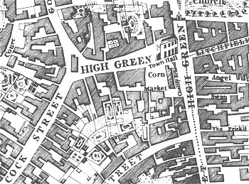
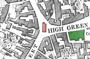
High Green from Isaac Taylor's map of 1750.
|
Wolverhampton centred, as it had for centuries before on
High Green, the old market patch. High Green ran from the junction of
Woolpack Street and Dudley Road, across Queen Square and up Lich Gates.
It also ran across Queen Square to the top of Darlington Street. There
was a late medieval cross standing on the east side of the Square at the
junction of the modern Queen Square and Dudley Street. In 1532 a market
hall was built near the cross, adjacent to where Staffordshire Building
Society is situated today. |
|
John Huntbach, who researched the now lost early Churchwarden’s
accounts, mentioned in his notes that the market hall was erected
“at the charge of the town”. The building measured 68ft. by 29ft. 4
inches and was later known as “The Old Town Hall”. It had a large
upper room (where the Assizes were held) that was supported by stone
pillars. The building was demolished in 1778 as a result of the
first Improvement Act of 1777 "for Widening, Cleansing and
Lighting the several Streets, Lanes, Alleys, Ways, and other public
Passages, within the Town of Wolverhampton, in the County of
Stafford, and for Taking down, Altering or Rebuilding certain
Buildings therein mentioned, and for removing all other Nuisances
and Encroachments, and for Regulating Carts and other Carriages
within the said Town." |
A close-up of Taylor's map showing the "Old Town
Hall".
|
|
William Addames, a Wolverhampton butcher was
granted a lease by John Leveson on 9th October 1577. This
is recorded in the
Sutherland Collection and describes Addames’ shop as follows “in the
South end of the Shambles Hall” with the “uprooms or buildings over
the same”. Another lease, also referred to in the collection, dated
23rd
March, 1630 calls the building “the Townehall in Wolverhampton”.
At the
northern end of modern Dudley Street was the Charity School, also
marked on Taylor’s map. It was purchased by the Town Commissioners
in 1779 to be demolished, like the market hall under the 1777 Act.
It was known as “Upper Butcher’s Row” or “Over Butcher’s Row” and
was owned by at least 5 vendors. The Wolverhampton Town Constables
Accounts state that both this building and the
market hall were used by the trustees of the school at various
times.
|
Dudley Street in 1835. From Noyes' drawing of
High Green. |
The Sutherland
Collection contains many details of High Green and states that the land
from modern day Woolpack Street to Queen Square was in the manor
of the Prebend of Hatherton, and included a medieval horse mill that
stood on the corner of Woolpack Street and Dudley Street. In 1609 a
detailed survey of Sir Walter Leveson’s Wolverhampton estates was
carried out and it includes details of the Swan Inn that stood where
Lloyds Bank is today. At the time the inn was leased to John Aldersey,
whose land went across to Piper’s Croft where there was a large barn. |
| Piper’s Croft was a large field, roughly in between
modern Queen Street and Castle Street. The Swan is also referred to in
the surviving Wolverhampton Town Deeds. Sir Richard Paget’s Oldfallings
deeds contain details of a lease dated 26th February, 1516.
The Swan was then owned by Richard Lane of the Hyde, Brewood and was
leased to John Baxter. At the time the Swan was being either wholly or
partially rebuilt after a fire. |
|
In the 1770s the town’s first theatre was built
in the yard behind the inn and described in a report in a
Wolverhampton Chronicle of 1894 as follows:
The building was a plain but substantial brick
structure about 80ft. long by 36ft. in breadth, with two entrances –
one to the boxes (or dress circle) facing down the Swan Yard, and
the other leading to the pit and gallery, being opposite the opening
or gateway entrance from Wheeler’s Fold. The interior was almost as
plain as the exterior, there being little attempt at artistic
embellishment or decoration, except in the vicinity of the stage,
which occupied the entire breadth of the building at the east end.
It is estimated that the theatre seated about 600
people.
Also listed in the 1609 survey is a large house
leased to Elizabeth Pershouse. The house was close to the swan and
the garden extended to Piper’s Croft. A nearby house and shop were
leased to John Wightwick and close by stood the houses of John Key
and Richard Shenton. Each house had a sizeable piece of land at the
back. Elizabeth Pershouse paid 30s a year rent for her house, John
Wightwick paid 31s.4d. a year and Richard Shenton paid 36s a year.
|
John Fullwood's drawing of 19th century shops in
High Green, Now Dudley Street. |
| The houses on the western side of the street appear to
have been smaller. One was rented by Henry Smythe who also rented
Culwalle Meadow and Whytmore Reaynes pasture from the Levesons.
At this time the southern end of Dudley Street was less populated.
Bell Street was then known as Hollow Lane and used to extent to
Dudley Street (until the 1970s). There were two houses in Dudley
Street adjoining the junction with Hollow Lane. The first was rented
by Richard Brett, who paid 15s a year and the other tenant, Hugh
Sambrooke, paid 16s.4d. a year. These cottages were opposite the
main entrance to the Old Hall, the Leveson’s home.
|
|
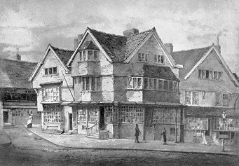
High Hall shortly before demolition. By R.
Noyes.
|
The Leveson family also owned a grand house on High
Green approximately where Wolverhampton’s Information Centre stands
today. It was known as High Hall and was a fine 16th
century half-timbered building that survived until1841.
The Sutherland Collection contains leases for the house from about 1620
to 1654, but many are badly damaged. One that has survived is dated 20th
April, 1654 and was granted by Sir Richard Leveson of Trentham to
William Normansell senior, for a term of 99 years.
|
|
The
rent was £10 per year with two fat hens at Christmas and two fat
capons at Easter. When the lease was granted he had to pay a heavy
£200 premium and Mr. Leveson reserved the right to use any of the
rooms in the house at will. The lease also included a great deal of
arable land, meadowland, pastures, closes and crofts, all in the
outskirts of Wolverhampton.
The
collection of Wolverhampton Town Deeds includes deeds for the house
from 1705 to 1841, when it was purchased by the Town Commissioners.
One carries an inventory of some of the rooms as they were in 1780
when the occupier was Peter Talbot, a mercer and draper. At the time
the business was taken over by James Hordern. By 1841 the house had
been divided into two parts, the upper shop and the lower shop.
Immediately behind High Hall in the early 19th century
were two inns known as “The Wheatsheaf” and “The Lamb” and on the
western side of the house was a block numbered 25, 26 and 27 High
Green. A deed from 1738 contains information on the block, much of
which was occupied by Sarah Unett and Thomas Bradshaw, an
apothecary. The gardens at the rear are visible on Taylor’s map and
were known as “The Little Garden” and “The Great Garden”. In 1899
the block was owned by Edgar Harley who ran “Harley’s Vaults” from
number 25, the remainder being rented to Messrs Picken and Waring
who were drapers.
|
| Taylor’s map
shows an isolated building at the western end of High Green, known as
“The Roundabout”. The ancient building stood in-between Cock Street and
Goat or Tup Street (now North Street).
It is described in one of
the Town Deeds dated 3rd August, 1682 as a burgage or
tenament owned by John Southwicke, a Wolverhampton saddler who sold
it to Jonathan Farrian and Thomas Skett for £220.
|
Part of Isaac Taylor's map of 1750. "The
Roundabout" is coloured in red and High Hall is coloured green. |
| Sometime
before 1783 the building had been divided into two halves because in
that year the half owned by Thomas Jarvis was acquired by the Town
Commissioners. From 1788 Samuel Adey, a mercer and draper occupied the
other half of the building. He sold it to the Town Commissioners in May
1815 and “The Roundabout” was demolished to make way for the building of
Darlington Street. One important feature associated with “The
Roundabout” was one of the town centre’s water pumps, which survived
after the building was demolished. The edition of the Wolverhampton
Chronicle for the 8th March, 1820 contains an article that
states that the materials from the building were sold by auction to the
highest bidder.
|
|
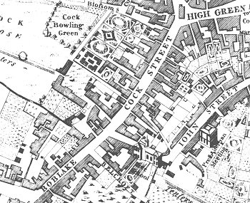
Cock Street and Boblake as shown on Taylor's map.
|
At the south
western corner of High Green was Cock Street and Boblake, renamed
Victoria Street after the Queen’s visit in 1866.
Cock Street was probably
named after the “Cock Inn”, which stood on the western side of the
street approximately opposite Lindy Lou’s, the only surviving 17th
century building in the street. The “Cock Inn” burned down on 22nd
April 1590 after one of the many fires that took place in the area
and destroyed many of the timber-framed buildings.
|
| In fact in
Barn Street, now Salop Street, 104 houses were bunt down and 694 men,
women and children were “impoverished by the fire” and 30 stacks of hay,
corn and straw were destroyed.
Cock Street was previously
known as Tunwell Street or Tunwalle Street, which is derived from
the words town well, the name is perpetuated in Townwell Fold. An
account of the wells can be found in Robert Plot’s “Natural History
of Staffordshire” from 1686. The wells were situated behind the
“Cock Inn” and so were roughly where Beatties store stands today.
The lower part of the Street (Boblake on Taylor’s map) was a marshy
area through which ran the town brook. It is called Puddle Brook on
Taylor’s map and ran down from Snow Hill towards Chapel Ash.
|
| On Taylor’s map,
at the eastern side of High Green is Lichfield Street. This ancient
street was originally called Kemstrete or Kempstrete, as stated in the
14th and 15th century Paget deeds. This name is
almost certainly derived from the medieval word for a “comb” and so is
another link with the wool trade. On the southern side of the street
stood Stirk’s Cooperage and the “Noah’s Ark” Inn where the early
Methodists met in a back room. Here they built the “Noah’s Ark Chapel”
in which John Wesley himself preached on a number of occasions, the last
being on 23rd
March, 1790. The proprietor at the time was William Horton who had
only been there for several months. In 1791 he advertised as a rum and
spirit dealer and became very active in the affairs of the town. His
niece was married to John Hargrove, who kept the “White Rose”, also in
Lichfield Street. On the northern side stood the Old Posthouse
and the “King of Prussia” Inn. |
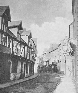
Old Lichfield Street before demolition in the
late 1870s. |
|
In the Town Deeds the Inn is described as a burgage house, which
carried the right to a pew in St. Peter’s Church. It stood on the
site of what is believed to have been the medieval Guildhall where
the wool merchants would have met.
A look at Taylor’s map reveals that in those days Lichfield Street
ran into Horsefair (now Wulfruna Street) via the modern day
Lichfield Passage and it remained as such until the wholesale
demolition and widening of the street in the 1880s.
This is but a brief glimpse into the old town and
much more can be found in the records by anyone wishing to visit the
local archives. The records can, with a little imagination almost
bring the old town back to life, which can’t be done in any other
way.
Bibliography
History of Wolverhampton to the Early Nineteenth
Century, Gerald P. Mander, M.A., F.S.A. and Norman W. Tildesley,
Wolverhampton C.B. Corporation, 1960.
Wolverhampton. The Early Town and Its History,
John S. Roper, M.A., Wolverhampton, 1966.
A History of Wolverhampton, Chris Upton,
Phillimore & Co. Ltd., 1998.
|

|
Return to the
previous page |
|