|
Beginnings
Walsall probably began as a small village, surrounding
the parish church, on the top of the hill. It slowly
expanded down the hill alongside the market, and on the
other side of Walsall Brook, where Park Street is today.
By the end of the 14th century, buildings were appearing
in Park Street.
For much of its early life, it was
an agricultural town, surrounded by fields and meadows.
As was usual in the Middle Ages, there were common
fields, farmed in strips. Although the fields are now
long gone, some of their names remain as place names,
and street names. Long
Street alongside the railway line is near to the site of Long
Meadow, which belonged to the lord of the manor, and lay
between Walsall Brook and the mill race. Wisemore is named after
Wisemore Meadow, held by 4 tenants, later becoming a
common field. Other common field names were Holbrook
Field, which lay alongside, and to the south of The
Holbrook, and Churchgreve Field, which lay to the south
of Holbrook Field. The boundary between the two fields
was roughly where Chuckery Road is today. Chuckery is derived from Churchgreve,
meaning a small wood, which later became the common
field. Cow Lane is named after the lane leading from
Ablewell Street to Churchgreve, which at one time was
used as pasture for cattle, sheep, and horses. Another common
field which formed part of Churchgreve Field was The
Lee, possibly known as Lordeslegh. Butts Road is
probably named after some of the triangular areas in the
fields that did not fit into the ploughing scheme. They
were known as butts.
To the south of the town were
Vicar's Field, Windmill field, and possibly a field
called Armescote. In 1305 the town's windmill probably
stood in Windmill Field. It was owned by Sir Roger de
Morteyn, who in 1306 gave it to Henry de Prestwode and
his son John. In 1318 John sold it to Ralph, Lord
Basset, and it remained as the lord of the manor’s mill
until 1393 when it was destroyed in a gale. |
An impression of the early layout of the town.
|
The
Manor House and The Park
Park Street is named after the lord
of the manor’s park, which surrounded the manor house
and extended from the top of Park Street, later called
Town End, alongside the Willenhall Road, as far as
Bentley Mill to the west, and Pleck to the south. It
covered around 260 acres of land and had large numbers
of oak and chestnut trees. The park was created by
William Ruffus, who kept a herd of deer there. In the
14th century, Ralph, Lord Basset kept thoroughbred
horses there. They were from his stud at Drayton. In the
1380s bullocks and oxen were fattened in the park. At
this time it was mainly wooded, and enclosed to protect
the timber, some of which was used for Walsall pillory
in 1396-97 and for the perimeter fence.
The Belle Vue pub in Moat Road
stands on what was the northern side of the moat. The
site of the manor house is just behind the Belle Vue pub
car park. In between 1972 and 1974 an archaeological
excavation took place on the site of the manor house.
The remains of the buildings were very fragmentary,
having been disturbed by gardening. It
revealed that the original house had been built on
agricultural land, consisting of ridge and furrow. It
was built in the early part of the
13th century. The stone sills of three timber buildings
were constructed on the ridges, one of which contained a
latrine. Another was possibly a forge because slag was
found there. The slag is typical of iron-working, and of
the type that could have been produced in a bloomery,
although it could equally have been the result of heavy
smithy operations. The slag has a dense thin layer which
was probably produced at the bottom of a hearth furnace,
likely in contact with charcoal. |
|
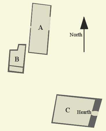
A plan of the excavated buildings inside the
moat. |
Building A
was a rectangular structure, 4 m by 11 m, initially
built of unmortared limestone across one of the ridges.
Internally the furrows were filled with yellow clay. The
building was later reconstructed after a layer of clay
had been placed over the wall footings and the floor. No
hearth or features were found in the building. It
appears to have been a forge.
Building B
had a continuous base supporting a row of columns,
possibly in classical Greek style. It measured 3.5 m by
4.5 m with a half-width extension at the northern end,
measuring 1.6 m by 1.3 m. The floor was clay covered,
and spotted with charcoal. In the eastern wall was a gap
that led to a culvert, which ran outside the southern edge of the
building, possibly part of a latrine. A small pile of
triangular tiles was discovered at the southern end of
the building.
Building C
was not excavated, only two exploratory trenches were
dug, the first across the west wall, and the second
along the east wall. As in the other buildings, the
furrows were filled with yellow clay. A hearth was
discovered in the east wall. |
|
Remains of an east-west foundation
wall were found at the southern end of the site,
indicating the location of another building. Much of the
building had been robbed-out, but what was left
consisted of fragments of internal partitions, a bake
oven, and two patches of burnt clay, possibly hearths.
The building included a room measuring 5 m by 5.7 m, but
the remains were at best fragmentary. Parts of another
building to the east were found, including the
foundations of a rectangular chimney measuring 2 m by
2.4 m. Just outside the building was a wood-lined well,
2 m square.
There were indications of a
building to the south of the well, built of unmortared
limestone. Unfortunately it extended beyond the southern
limit of the excavation. The building with the bake oven
and hearths is thought to be the kitchen, the building
with the chimney, residential, probably the hall itself,
and the building to the south was possibly an open shed.
The construction of the moat seems
to have involved the diversion of a stream, which flowed
northwards along the west side of the site. The stream, now culverted,
still exists, and flows beneath the houses to the north
of the site. The north arm of the moat, and the northern
ends of the east and west arms had been filled-in
sometime before 1884 when a row of houses was built upon
them. During the second half of the 19th century the
southern part of the site was a garden containing two
ranges of greenhouses. In the 1920s a bowling green and
pavilion were built on the
northern part of the site, with allotments to the south.
The site was acquired by the West Midlands Regional
Hospital Board in 1972, for redevelopment.
The manor house was probably built by William Ruffus, at the same time as the creation of the park.
After William’s death in 1247 it passed to his eldest
daughter Emecina, then around 1275 it was taken over by
her son Sir William de Morteyn. After his death in 1283
it was passed on to his nephew Roger de Morteyn, and in
1314 to Ralph, Lord Basset of Drayton.
It seems likely that Ralph’s son
and daughter-in-law lived in the house, or at least
occupied it for a time, because his grandson and heir,
Ralph, was born in Walsall in 1333. Around this time a
moat with a drawbridge was built around the house. The
Basset family seem to have used the house for many years
because in 1388-89 the roof was repaired, and a wooden
belfry was built for the chapel. A new drawbridge was
built over the moat, and the large heavy gates were
reinforced with iron. After Ralph’s death in 1390 the
house may have only been used occasionally. It was
abandoned in the 1430s, and the fishing rights for the
moat, known as ‘le Mote’ were leased to the bailiff of
the ‘Foreign’. The house must have fallen into disrepair
because it had been demolished by 1576.
By the early 1400s much of the land
in the park was leased out, and cleared for agricultural
use. In 1859 part of the area was opened as a public
park called ‘Moat Garden’ using the moat as a feature.
But the venture was unsuccessful and the park soon
closed.
W. Henry Robinson mentions, in his
"Guide to Walsall", a once famous spring called "Alum
Well" which was in a field on the eastern side of the
moat. |
| |
|
| View a list of the Lords of
the Manor of Walsall |
 |
| |
|
|
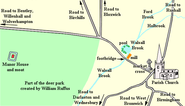
Park Street, The Bridge and Walsall
Mill
Park Street follows the line of the
old road from the manor house and park into the early
town. Town End at the top of Park Street was possibly
the ‘head of the town’ which is mentioned in the charter
of 1309, which allowed the burgesses of Walsall (the
higher status members of society), the right to hold
their own courts, and also began to regulate the
separation between the centre of Walsall (the Borough)
and the outlying areas, known as the Foreign. At Town
End, Park Street divided into three, one road leading to
the park, the manor house, Willenhall and Wolverhampton,
a second leading to Birchills, and a third leading to
Bloxwich.
The other end of Park Street led to
The Bridge, originally a small footbridge
across Walsall Brook, which now runs in a culvert. The
bridge was first recorded in the 13th century. Walsall
Brook flows southwards to Bescot Brook and the river
Tame, and is fed from the north by two streams, The
Holbrook, which rises near Rushall Canal, and Ford Brook
which flows from Aldridge. The confluence of the two
streams is near the Gala Baths. Just north of the old
footbridge, near to where Sister Dora’s statue now
stands, was the lord of the manor’s water mill, and the
mill pool, which extended from the brook across to the
area now occupied by St. Paul’s Church. The pool was
known as ‘The great fish stew’.
This may have been the great
fishpond of Walsall, which was owned by Emecina and
Geoffrey de Bakepuse, and in 1248 leased to her sister
Margery, and her mother Isabel, widow of William Ruffus.
In 1275 when Emecina’s son, Sir William de Morteyn, took
over the running of her estate, he acquired the
fishpond, which he owned until his death in 1283.
|
|
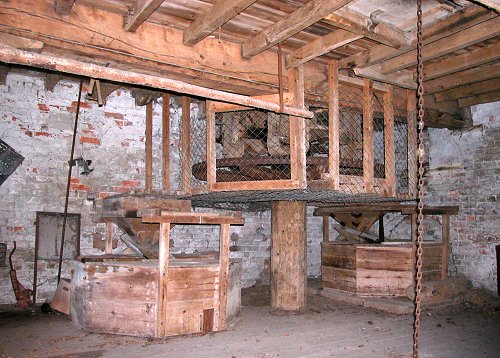
An impression of how the interior
of the mill may have looked. |
The water mill was known by
several names; Walsall Mill, Town Mill, the Ford Mill,
the Old Mill, and the Malt Mill.
In 1395-96 Jenkyn Cole, of Walsall
Mill complained that the burgesses of the town would not
grind their corn at his mill, instead taking it to other
mills including the one at Rushall.
He was advised to
get a more cunning miller to regain their goodwill.
By 1763 the mill had closed.
|
|
Early roads, and the early village
The track across the footbridge led
to what is now Digbeth and High Street, and on to the
parish church, and the original settlement. High Street
has been the site of the market since 1220 when a Royal
grant gave William Ruffus, Lord of the Manor, the right
to hold a weekly market on Mondays, and a fair on the
21st of September, St.
Matthew's day, and on its eve. In
1399 another fair was added on the 24th June and on its
eve, celebrating the Nativity of St. John the Baptist.
In 1417 market day changed to Tuesday when Richard
Beauchamp, Earl of Warwick, and Lord of the Manor of
Walsall,
granted a Tuesday market, and two fairs every year, one
on October the 28th (St. Simon and St. Jude's day) and
another on May the 6th (the feast of St. John).
Walsall became an important market
town, selling mainly farming produce for many centuries.
By 1386 a market cross had been erected at the top of
High Street, in the centre of the road, near to its
junction with Upper Rushall Street, which probably
existed in the early 13th century as the road to
Lichfield. It had been named by 1339.
The road southwards from the
junction of High Street and Upper Lichfield Street, now
called Peal Street, was the road to Birmingham, West
Bromwich, Darlaston, and Wednesbury. It was known as
Hole End in the 14th century, and also Newgate Street.
Before the building of Bradford
Street in 1831, the route to Darlaston and Wednesbury
ran along Peal Street, Dudley Street, and Vicarage Place
to join the existing Wednesbury Road. The route to West
Bromwich started at Peal Street, and ran along New
Street, Sandwell Street, and West Bromwich Road. It was
certainly there well before 1452, because in that year
Thomas Mollesley left money for the building of a new
bridge (Tame Bridge) in West Bromwich Road, on the old
Walsall and West Bromwich boundary. The road to
Birmingham was probably in use by the middle of
the 13th century. It ran from New Street, through Birmingham
Street to Birmingham Road.
The parish church has stood at the
top of the hill since around 1200. It was originally
dedicated to All Saints, and still has its 13th century
crypt, which is the oldest surviving building in the
town. The church itself has been extensively rebuilt
since those early days, and must look very different to
its original form.
The initial settlement and the
early town grew up around the church, and would have
consisted of simple wooden buildings. Most occupants
lived in the town centre. The surrounding areas,
known as the ‘Foreign’, included Bescot, Caldmore, and
Walsall Wood, which were tiny hamlets with only a few
inhabitants, whereas Bloxwich, also part of the
'Foreign' was bigger.
The feudal system introduced by the
Normans ensured that the tenants had to fulfil their
obligations to the lord of the manor. They included
working his land, and harvesting his corn. It would have
been an extremely hard life. |

Medieval farming.
|
In the late 1340s, the Black Death,
or plague as it was known, swept through the country,
killing large numbers of people. It returned in 1361,
and again in the 1370s and 1380s, by which time only ten
percent of the working classes remained. This changed
the relationship between the lord and his tenants, and
brought about an early end to feudalism. Peasants were
now in short supply and many farming communities
disappeared. They could now dictate their own wage
levels and terms of employment. In 1401 the tenants in
Walsall refused to pay their rents in lieu of services
and went on strike.
Although the main occupation in the
town during the Middle Ages was farming, there is
evidence of industrial activity in the 14th century. In
1300 the Manor of Walsall was divided into two parts,
the first part owned by Roger de Morteyn, and the second
part by Margery Ruffus (le Rous). They agreed to share
the profits of the coal and ironstone mines in the
manor. Margery’s son, Sir Thomas le Rous reserved the
right to license coal-mining on land at Birchills in
1326 and 1327. By the late 1380s, and 1390s, there
were mines in Windmill field.
By 1300 there was a fulling mill at
Walsall, and cloth was made in the town by the middle of
the 15th century. In 1309 a charter granted by the lords
of the manor to the burgesses
stipulated that the market-place should be kept clean.
Charters and Burgesses
In the Middle Ages the higher
status members of the community were known as burgesses.
They were often the more skilled members of society, who
were householders,
and did not have the manorial obligations of serfs. They
paid rent and could run their own lives with more
freedom. They had special privileges that derived
from their support of the community, and played an
important part in the early life of the town.
In 1225 a charter granted by
William Ruffus gave the burgesses freedom from paying
most of the feudal tolls and customs, in return for an
annual fee of 12 marks of silver. He also allowed them
to keep their swine in the manorial park, to feed on the
acorns when they fell
from the trees. They were charged one penny per beast
for the privilege. A second charter granted in 1309 gave
them further benefits, including the right to hold their
own courts. They were an influential group of privileged
people, one of whom was the first mayor of Walsall,
although his name is not known. This is mentioned in the
Burgess Roll, which was kept from 1377 until 1619, and
presented to the town by Walter Sneyd, of Keele Hall. It also includes
a reference to Walsall’s first town council. It was only
possible to become a burgess, with the agreement of the
other burgesses, and the payment of a sum of money.
The Burgess Roll contains entries
relating to the admission of people into their group:
Walter Fletcher came amongst the
said Burgesses and gave them 2s.4d that he might enjoy
the freedom of the Burgesses of the town aforesaid, as
in a certain Charter by the Lords of the Manor of
Walsall, to them thereof granted is more fully
contained. And he did fealty to the Burgesses…..
Roger Mollesley was received as a
Burgess, and gave 2 shillings for a fine…….
Henry Mylleward de Ruschale was
received as a Burgess, and gave for a fine 6s.8d because
he was not of the Manor, nor Tenant within the Manor.
Richard Bridgend of Rushall Street
was received as a Burgess to this extent, that he might
enjoy etc., and he gave 6s.8d for a fine, and did fealty
to the Burgesses.
Henry Marchall of Walsall was
received as a Burgess, and paid forthwith 6s.8d, and did
fealty to the Burbesses.
Richard Wever, heir to the
aforesaid Henry, was received a Burgess by descent from
the aforesaid Henry Marchall. (Wever was probably the
son of Marchall’s daughter)
It seems that prospective members
who lived within the Borough had to pay 2s.4d to join,
whereas people living in the Foreign were charged 6s.8d.
The Foreign Burgesses received the full privileges that
had been given to the other members, including immunity
from paying tolls.
They had many privileges including
the right to keep animal pens at the market, and the use
of common pasture in the waste, which consisted of
several commons including Birchills, Blakenall, Dead
Man's Heath, Pleck, Short Heath, and Wallington.
It seems that there must have been
a school in Walsall in 1377 because a schoolmaster named
Robert became a burgess in that year.
|
|
By the 15th century the hall of St.
John’s Guild in High Street (built by 1416) became the
seat of local government. The Guild of St. John was founded in the late 14th century, as a religious
organisation with a special alter in the parish church.
It had a social and political role, and was closely
associated with the town council. Many members of the
guild were burgesses.
On the 6th October, 1399 King Henry
IV gave a grant to the men of Walsall which freed them
from the payment of tolls when travelling anywhere in
the country. This privilege was enjoyed by many other
towns including Wednesbury and Coventry. It seems that
the charter was granted as a concession to Thomas de
Beauchamp, Earl of Warwick, and Lord of the Manor of
Walsall, after his titles and estates were restored to
him. He was one of the Lords Appellant who tried to
separate King Richard II from his favourites in 1387.
Richard saw him as a potential enemy, and charged him
with high treason in 1397, supposedly as a part of the
Earl of Arundel's alleged conspiracy. |

The arms of Thomas de Beauchamp. |
|
Beauchamp was imprisoned in the
Tower of London, in what is now known as the Beauchamp
Tower. He pleaded guilty, and forfeited his estates. He
threw himself on the mercy of the king, and was
sentenced to life imprisonment on the Isle of Man. In
1398 he was moved back to the Tower, where he stayed
until his release in August 1399. Henry Bolingbroke had
deposed the king and became King Henry IV, who restored
Beauchamp’s titles and estates, and gave the grant to
the men of Walsall.
A curious code of laws was made in
the Borough in the 15th century, for the “continuance of
gode rule”. It regulated the playing of “unlawefull games,
except in Cristemas, as dyce, tables, cares, cloch,
tenes, foteball, or eny other lyke”.
An important benefactor was Thomas
Mollesley of the Manor of Bascote, who died in 1451. He
arranged that after his death, a dole was to be given out
in his memory, and distributed to every man, woman, and
child, resident in the Borough and Foreign of Walsall.
It was administered by the Guild of St. John, and given
out on Twelfth Night (6th January). The dole was
distributed every year until 1825. Distributors visited
every house, and gave one penny to every person in the
Manor. Legend has it that Thomas Mollesley was riding
through Walsall on the day before Twelfth Night and
heard a child crying for food. He decided to bequeath
his land at Bascote so that this could never happen
again.
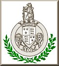
Walsall took its Coat of Arms,
which includes the Warwick emblem of the "Bear and
Ragged Staff" from the town’s association with the Earls
of Warwick, who were lords of the Manor of Walsall for
nearly 100 years.
By this time Walsall was a
thriving, and growing market town, with a successful
farming community, and the beginnings of its industrial
future. There were 367 poll-tax payers in 1377. It was
an affluent town with a complex social structure, a town
council, and a bright future ahead.
|
 |
|
|
|
|
Return to
Origins |
|
Return to
the beginning |
|
Proceed
to 16th, 17th centuries |
|