|
There would have been a tiny
settlement in the area by the 8th century when the
town’s name was first recorded. Willenhall lay in part
of Cannock Forest, an area much favoured by the Mercian
Kings for hunting the wild boar,
wolves, and possibly deer, that resided here. It seems likely that King Aethelbald, who came to power in 716, used the hamlet as
a centre for his hunting activities. In the 22nd year of
his reign he signed a charter at the hamlet, to reduce
certain taxes payable by the Abbey of Minstry in the
Isle of Thanet. He did this for the good of his soul,
and to help ensure a place in the afterlife.
The contents of the charter were
recorded in original Latin by John Mitchell Kemble in
his 6 volume “Codex Diplomaticus Aevi Saxonici”, printed
in 1839 to 1848. Kemble made an extensive study of
Anglo-Saxon, and Norman legal and administrative
documents, from the British Museum, his own collection,
and various libraries. The contents of the charter were
also published in the original Latin form in Thorpe’s
“Diplomatarium Anglicum” in 1865, and Birch’s
“Chartularium Saxonicum” in 1885.
The charter is worded as follows:
| From sinful Aethelbald, King of the
Mercians, who yields to Mildrith, Abbess of Minster, the
tax on a ship of burden, and grants that throughout the
kingdom it remains free of royal tribute. I, Aethelbald,
King of the Mercians, perform, as far as in my power
lies, acts of gratitude to Almighty God, who has deemed
me worthy to be chosen for so high a grade of
distinction, out of the humble and unquiet life which I
led for the space of so many years.
Therefore, for the
salvation of my soul, and in return for the liberal
offerings of the prayers of holy servants and handmaids
of God, I freely bestow upon the churches of God, those
things which are brought under my power, and the
bounteous gifts of our Almighty Lord and Saviour Jesus
Christ. And to thee Abbess Mildrith, and to thy church,
I give up and remit tax due upon a ship of burden, which
is gathered by way of tribute by our toll collectors, so
that throughout the kingdom the ship may remain free
from all royal impost and tax.
If any attempt to infringe upon
this gift we have granted, either in great part or in
small, let him know that he remains expelled from our
communion, and wholly cut off from the company of the
pious.
Signed by Aethelbald, Cuthraed,
Sileraed, Worr, Cotta, Cynric, Wilfred, Lulla, and Oba.
This was excecuted on the fourth
day of the Kalends of November, in the 22nd year of our
reign in the place which is called Willanhalch.
|
A second copy of the charter also
survives, which states that this is the 15th decree made
in the place which is called Willanhalch.
The well-known, acknowledged, 19th
century authority on Saxon place names was William Henry
Duignan, a Walsall Solicitor, who wrote books about place names in Staffordshire, Warwickshire and
Worcestershire. He stated that the name Willanhalch
cannot be applied to any other place in Mercia, or Saxon
England, than Willenhall in Staffordshire. There is
another Willenhall on the outskirts of Coventry, but
that was known as Wylnhale, and any charter signed there
would include the Coventry name.
Willanhalch in Anglo Saxon means
the meadowland of Willan, presumably the local land
owner, head of the ruling family, or local chieftain.
The old English word for meadowland, ‘halch’, was
shortened and modified in the course of time to ‘hall’.
Other similarly modified local place names include:
|
Tettenhall |
Possibly Tetta’s hall |
| Pelsall |
Peol’s hall |
| Codsall |
Code’s hall |
| Ettingshall |
Hall of the Etti
family |
By the 12th century the name had
changed to Willenhale, and Willenhal.
In the year 913 Stafford became a
secure, fortified stronghold, under Queen Aethelfaed,
and soon replaced Tamworth as the capital of Mercia.
Within a few years the new Shire of Stafford was formed.
At this time the country was divided into ‘Hundreds’,
each consisting of an area which roughly supported 100
households. The Shire of Stafford was divided into 5
'hundreds'; Cuttlestone, Offlow, Pirehill, Seisdon and
Totmonslow. Willenhall was part of The Hundred of Offlow.
Each hundred was headed by a hundred-man or hundred
elder, who oversaw justice and administration in the
area, organised the supply of soldiers, and led them
into battle. Hundreds were usually named after the place
where meetings were held to discuss local issues, and
where trials took place.
At this time Willenhall would have
been a small hamlet, consisting of a few single-storey
timber-framed buildings, possibly clad with timber, or
even wattle and daub, and covered with a thatched, or
turfed roof. Timber would have been in plentiful supply
and so was an obvious building material. There would
have been a hearth for a fire, but no chimney, the smoke
escaped through the roof. All the furniture such as
beds, benches and tables would have been made of wood.
Valuable items and tools would have been stored in a
wooden chest.
Some Saxon houses were built above
a hole, up to 9 feet deep, which may have been a
basement below a wooden floor. Around the houses would be farm
land for crops, and grazing for cattle.
Under new ownership
By 1086 Willenhall had come under
the control of Wolverhampton, but some of the events
that led to this are unclear.
According to tradition, King
Wulfhere founded the Abbey of St. Mary at Wolverhampton
(on the site of St. Peter’s Church) in 659, but there is
no proof of this. However in 985 King Aethelred gave
several pieces of land to Lady Wulfrun in a royal
charter, including Bilston, Sedgley, Wednesfield, Upper
Penn, and Trescott. In his charter Aethelred describes
the area of land in terms of its boundaries.
In 994 the Lady Wulfrun gave the
pieces of land to the Abbey of St. Mary ‘for the good of
her soul’. The gift included Bilston, but made no
mention of Willenhall. The Domesday Book of 1086 does
include a reference to Willenhall, stating that part of
it belongs to the church; the Deanery Manor of
Wolverhampton, (St. Mary’s), and the remainder belongs
to the King, becoming part Stow Heath Manor in
Wolverhampton. At this time Bilston no longer belonged
to St. Mary’s, it was partly owned by Stow Heath Manor,
and partly by the Deanery Manor of Wolverhampton. It is
possible that an exchange of land was made between the
King and St. Mary’s, so that part of Willenhall came
under the ownership of St. Mary’s, and part of Bilston
belonged to Stow Heath Manor.
Norman Britain
After the Norman invasion in 1066,
William the Conqueror made it known that he personally
owned all of the land in the country. He appointed
around 200 barons as tenants in chief, and allowed them
to hold large areas of land, in exchange for the payment
of taxes, and the provision of soldiers when necessary.
The system, known later as feudalism was the key to the
Norman’s success.
The Normans held on to the Saxon
‘Hundreds’, but carved-up the land into areas called
manors, each controlled by a baron, or Norman Lord. They
had to take an oath of loyalty to the King, carry-out
any required duties, and pay taxes for their land. Each
manor would include several villages whose inhabitants
were called peasants. There were several classes of
peasant. The highest was a freeman who was free to
pursue a trade. The other classes were owned as part of
the land, and were not free to move around.
In 1085 the Danes threatened to
invade, and so William decided to commission a detailed
audit of the country, to extract all of the taxes owed
to him, and to ensure that he got the maximum number of
soldiers to deal with the expected invasion force. The
survey was so detailed that an entry in the Anglo Saxon
Chronicle states that ‘not even an ox, or a cow, or a
swine was not set down in his writ.’ It seemed so
invasive, and all-seeing, that it felt as though
judgement day had come. As a result it became known as
the Doomsday Book.
All 400 pages of the book, record
in extraordinary detail, how the Normans organised their
new kingdom. The entry for Willenhall is as follows:
|
Land of the King
The King holds Winehala. There are
3 hides. The land is 4 carucates. There are 5 villeins
and 3 cottagers, with 3 ploughs. There is one acre of
meadow. The value is 20 shillings.
|
|
Land of the Clergy of Handone
The Canons themselves hold 2 hides
in Winehala. The land is one carucate. There are 3
villeins and 5 cottagers having 3 ploughs.
|
The King had 3 hides, each would be
approximately 120 acres, and 4 carucates, each being an
area of land equal to the amount that could be worked by
a team of 8 oxen. He also owned 1 acre of meadowland.
The 5 villeins were nominally free inhabitants of the
village, who worked the King’s land in return for a
small piece of land to work themselves. They also paid
rent. The 5 cottagers were peasants, lower on the social
ladder than a villain, with fewer privileges. The 3
ploughs meant that there was enough land on the estate
for 3 teams of 8 oxen to cultivate. It was also used to
assess the value of the estate for taxation.
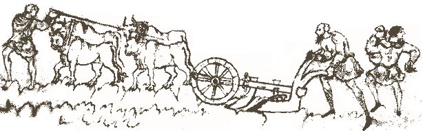
Oxen pulling a plough.
The church’s land was much smaller
(one quarter of the size), with no meadowland, 3
villeins and 5 peasants. Its taxable value would have
been far less.
Everything on the estate would have
been owned and controlled by the manor, or the clergy,
including property, money, religion, and even marriage.
There were labour services to do on the land, and heavy
rents to be paid. The majority of food produced, and
animals reared, were consumed by the lord of the manor
and his household. Many families lived off a simple
vegetable soup called pottage. The average life
expectancy at the time was just 25.
|