The Prehistoric Era

The West Midlands and South Staffordshire was an area of dense woodland interrupted only by local rivers and streams. It would seem that the area was largely unoccupied until Saxon times, even the Romans left few traces here. There is some evidence of prehistoric rambling taking place in the area and it is likely that there would have been a very small local settlement. In 1928 half a sandstone axe head from about 1200 B.C. was found in the Wolverhampton Grammar School playing field near Graiseley Brook at Merridale1. A bronze palstave axe from 600 B.C. was found in a garden in Finchfield and similar tools have been found at Bushbury, Cannock and Wrottesley. A polished flint axe head was found at Ashmore, Wednesfield in the 1880s and another was found in Stafford Street, Willenhall around 1920. In 1963 a flint scraper from around 6000 B.C. was found on Goldthorn Hill close to the Park Hall Hotel2, which proves that man has had a presence in the Penn area for at least 8,000 years. It is impossible to draw any conclusion about what was happening here in prehistoric times with so little evidence, and any further evidence has at best been covered up, or worse been destroyed by the prolific urbanisation and industrialisation that characterises the area.

The Roman Era

Even though the Romans occupied this country for four centuries, they left few traces behind them in the Penn area. There were many forts and settlements throughout the country which were linked by an excellent network of roads and one of these must have passed through Lower Penn. The nearest Roman sites are at Greensforge, Penkridge, Wall Heath and Edgbaston. Greensforge lies to the south of Wombourne by the Staffordshire and Worcestershire canal and includes a Roman military site. There were two forts, one situated on either side of Mile Flat, next to where the Navigation Inn now stands and the other to the south. There were also six marching camps that were used as overnight stops for armies that were on the move.


Roman Roads in the Penn area.

The first fort to be discovered was excavated in 1927 by a group of “past and present members of the Wolverhampton Grammar School” and was led by H.R. Thomas and G.P. Mander3. Gerald Mander produced a full account of the excavation and this can be found in the “William Salt Archaeological Society Proceedings of 1927”. A large number of finds were made and these were examined by two of the leading authorities of the day; Dr. Cyril Fox, Director of the Museum of Wales and Professor Donald Atkinson of Manchester University. They concluded that it was built during the time of Emperor Claudius 1st who added Britain to the Roman Empire and ruled from 10 B.C. to A.D. 54. The pottery remains indicated that it consisted of a semi-permanent military settlement followed by a small civilian settlement, which survived until the end of the first century. In the 1950s aerial photographs were studied and it was realised that the site is more complex than was first thought. In 1953 Professor J.K. St. Joseph published details of the aerial photographs4
He realised that the fort had an annexe to the south-east and there were other ditches on the east and on the south, which suggested that more than one period of occupation was represented.

A second and smaller fort was discovered to the south from aerial photographs in 1957 and the existence of three gates and ditches in the enclosure was mentioned in the “Journal of Roman Studies” in 1961.

Dr. Graham Webster published a description of the forts and a diagram showing the series of ditches between them in 19625. Professor J.K. St. Joseph suggested that the second fort occupied a more defensible position on a small promontory and possessed a staggered ditch arrangement in front of a single eastern gateway. The Kidderminster Archaeological Society carried out a small excavation in 1965. The finds dated the fort to the second half of the first century. It was suggested in 19666 that the fort housed about 500 men. In 1968 another small excavation by the Kidderminster Archaeological Society found 14 coins from A.D. 64, gaming counters and numerous small finds.


Roman sites around Greensforge.

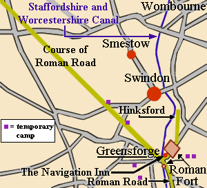
A temporary camp due east of Whitehouse Farm, close to the course of the Roman Road was discovered in 1969. It could easily have housed an entire legion of 5,000 men and could have been a temporary marching camp for the 14th Legion, who established Wroxeter in A.D. 47. Three more temporary camps were discovered from aerial photographs and field walking, and numerous finds of civilian material were made in the 1970s in an area south of Camp Hill7.

All in all this is an important site, which held the largest local population up to that time. It was linked by a number of roads to other forts and centres of population. To the south was the road to Droitwich, Worcester and Gloucester, and to the north-west was the road to Bridgnorth, 
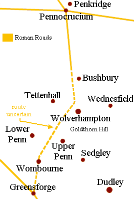
Wroxeter and Wales. To the North was the road to Watling Street and Pennocrucium, which was built near to modern Penkridge and would have passed through Lower Penn.

The northern course of the road from Greensforge is only known for the first half mile to Hinksford8. The southerly course from Pennocrucium is known as far as Pendeford9. The section through the western outskirts of Wolverhampton to Wombourne and Hinksford has not been discovered and much of it will have been lost due to the large areas of housing that now covers much of it. The road would have gone very close to where the Dovecote now stands at Pendeford, through to Claregate, Newbridge, Compton, Castlecroft, Lower Penn, Wombourne and Hinksford. This was probably the first road to have been built in Penn.

If the road was fairly straight it could have gone directly through the centre of Lower Penn, or to Lower Penn Farm and across the hill to Orton, to roughly follow Orton Lane into Wombourne. It could have equally have gone over Orton Hill past Bearnett Farm. Modern day farming has probably removed most of the traces that are left, but modern archaeology and field walking may one day locate the exact course of the road.

References

1).  Gerald P. Mander, A History of Wolverhampton to the Early Nineteenth Century, Wolverhampton, 1960, p.1

2).  Angus Dunphy, A Millennium History of Lower Penn, 2000

3).  David Cox, Greensforge Roman Sites, The BlackCountryman, vol. 30, no. 3, pp. 60-63.

4).  Professor J.K. St. Joseph, Journal of Roman Studies. Vol.XLIII, 1953

5).  Dr. Graham Webster, Birmingham Archaeological Society Transactions, vol. 80, 1962.

6).  An account of the Greensforge forts based on aerial photographs, Antiquity vol. XL, 1966.

7).  Dr. Graham Webster, Transactions of the Birminghan and Warwickshire Archaeological Society, vol. 91, 1981.

8).  The northerly course of the road starts at map reference SO864888 and has been traced to map reference SO867900. Ordnance Survey, Explorer Series, no. 219.

9).  The southerly course of the road has been traced to map reference SO896038. Ordnance Survey, Explorer Series, no. 219.


Return to
Contents
Return to the
Penn section
Proceed to Anglo-
Saxon Mercia