| Before colonisation, South Staffordshire and the
West Midlands was an area covered by forest, scrub and marsh.
People moving into the area would have taken the easiest routes
such as river valleys, or followed the higher ground on top of
the low hills that are an important feature here.
The area was initially colonised by the Anglo-Saxons from
about 520. They came from France, the Netherlands, Germany and
Denmark. Angles and Saxons first reached our shores during the
Roman occupation and were mentioned by the Roman historian
Ammianus Marcellinus who considered them as barbarians along
with the Picts and Scots. He mentions raids in 365, and the
mid-fifth century Gallic Chronicle mentions a large raid in 410
after the Roman army had departed. |
 |
At this time there were frequent raids by
continental pirates and many towns employed mercenary soldiers
for protection. These soldiers were Angles and Saxons from
northern Germany who brought their families with them and were
given farmland as payment for their services. Soon the
mercenaries realised that they were stronger than their
employers and so began to take over the running of many areas.
The Anglo-Saxons slowly colonised England, moving northwards and
westwards, pushing the native Celts into Cornwall, Wales and
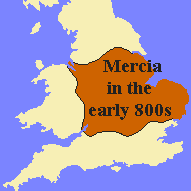
Scotland. By 850 A.D. there were three competing kingdoms;
Mercia, Northumbria and Wessex. |
| South Staffordshire was a part of Mercia, which
was derived from the old English word “Mierce”, meaning People
of the Boundaries. The kingdom developed from settlements in the
upper Trent valley and was colonised by a band of Angles called
the Iclingas. Slowly the area was populated and the kingdoms of
the Saxon and Angles in the midlands amalgamated to form the
kingdom of Mercia. |
| Read about the
Anglo-Saxons |
 |
|
Settlers moving into the area would have found or
made clearings in the woodland to build their houses, keep their cattle
and grow their crops. Evidence for such clearings and settlements can be
found in many of the names of local towns. The old English word “leah”
means a woodland clearing and can be found in the following place names:
Bentley, Brierley Hill, Coseley, Cradley Heath,
Dudley, Graiseley, Himley, Moseley, Oxley, Sedgley and Wordsley and
Wrottesley.
The old English word “halh” meaning a pocket of
land appears in the following names:
Blakenhall, Ettingshall, Tettenhall and Willenhall.
The old English word “tun” means a settlement and
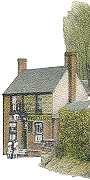
this is found in Bilston, Darlaston and Wolverhampton. Penn is the old
English word for a hill or promontory which must refer to the high
ground around St. Bartholomew’s Church.
|
|
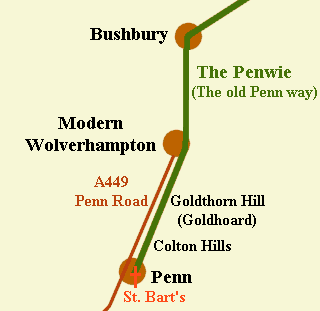
There was an ancient track leading from Bushbury to
Upper Penn called the “Penwie”1, which doubtless meant Penn
way. It ran along the old Cannock Road from northeast to southwest and
joined the old Stafford Road at Bushbury, from where it went to the site
of present day Wolverhampton. The track ran southwards across the centre
of the modern City and near to present day Pool Street to run parallel
with the Penn Road to Goldthorn Hill, which was called “Goldhoard”. From
here it ran across the Colton Hills to the site of St. Bartholomew’s
Church.
|
 |
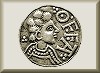
There must have been an Anglo-Saxon community in the centre of
Wolverhampton. According to tradition King Wulfhere founded the Abbey of
St. Mary at Wolverhampton (now St. Peter’s Church) in 659, but there is
no proof of this. However in 985 King Ethelred gave two pieces of land
to Lady Wulfrun. The first piece of land was at Trescott near Lower Penn
and the second included much of Wolverhampton. In his charter Ethelred
describes the area of land in terms of its boundaries. The boundaries in
Wolverhampton were roughly Gorsebrook Road in the north, Smestow Brook
in the west, Bilston and Sedgley to the east and Penn Brook (called loud
brook) to the south, so Upper Penn was included in the gift. The charter
is interesting because it proves that in 985 the boundaries between
Wolverhampton, Bilston and Sedgley already existed and prior to this
date Upper Penn belonged to Ethelred and later Wulfruna.
The Anglo-Saxon Chronicle mentions a battle in which King Edward
defeated the Danes in 910 at Tettenhall (Tootenhall):
This year the Angles and the Danes fought at Tootenhall; and the
Angles had the victory.
The exact site of the battle is unknown. It could have taken place at
Tettenhall or could have been on high ground near Wolverhampton. Some
historians have even suggested that it took place near Wednesfield
because of its link with the old god Woden (Wednesfield = Woden's
plain).
| In 1912 the base of a Saxon preaching cross was
discovered next to St. Bartholomew’s Church. This has been
attributed to Leofric, the Earl of Mercia and his wife Godiva.
Godiva owned Lower Penn and her son Algar owned Upper Penn.
References
1).
Gerald P. Mander, A History of Wolverhampton to the Early
Nineteenth Century, Wolverhampton, 1960, p.2
|
|
|
|
|

|
| Return to
pre history & the Romans |
|
Return to
the contents |
|
Proceed to
Godiva, Leofric and Algar |
|