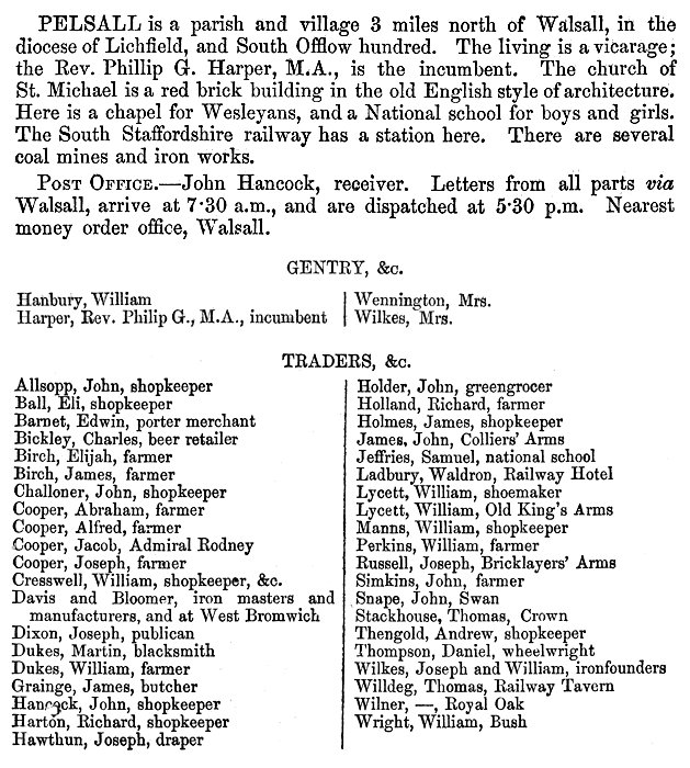
|
Early history
In 985, King Ethelred gave several
large pieces of land to Lady Wulfrun, an Anglo-Saxon
noblewoman and landowner. He granted the land to her in
a charter. Nine years later she gave several pieces of
land to the Monastery of St. Mary in Wolverhampton (now
St. Peter’s Church), including land at Bilston,
Brownhills, Willenhall, and Pelsall, then called
Peolshale. The land became part of the Deanery manor
under the control of the Canons of Wolverhampton, until
after the Norman Conquest when it became Crown property.
The Domesday Book described
Peolshale as half a hide of 'waste', belonging to the
Canons of Wolverhampton. The term ‘waste’ meant that no
taxes were collected from it, possibly because it was
uninhabited. Half a hide of land was about 60 acres. At
that time the area was covered by dense woodland and was
part of Cannock Forest. King William gave Peolshale to
fellow Norman, Robert de Corbeuil, for his assistance in
the conquest. Robert de Corbeuil’s descendants soon
included the territorial title 'de Pelshall' in
their name, which eventually was shortened to 'Pelshall'. The name
survived until the granddaughter of the last Sir Thomas
Pelshall, married the Earl of Breadalbane, in the 18th
century.
Little is known of Pelsall’s early
history. Ernest James Homeshaw, in his book ‘The Story
of Bloxwich’ published in 1955, includes a reference to
a document in the British Library, dated 1215 to 1224
that refers to a mill at Peleshale. This could have been
beside the Clockmill Brook that flows to Goscote, which
is considered to be the site of the earliest settlement
in the area. In 1286 Robert the miller had two acres of
land, possibly by the mill.
The Staffordshire Assize Roll of
1272 includes a reference to John de Chelesle, who
chased and caught William, son of Robert de Thene, and
Adam, son of Alote, on the heath at Norton. He accused
them of breaking into his Lord's grange at Pyshalle,
then bound and beheaded them. He was arrested for
the brutal act and taken to the Bishop's prison at Eccleshale, from where he quickly escaped. He was soon
recaptured and later beheaded.
At this time the area was still
part of Cannock Forest, the chief forester being Phillip
de Montgomery who in 1294 had two acres of rent-free
land. In 1300 the forest at Pelsall ceased to be part of
Cannock Forest and so was freed from the strict forest
laws. This allowed the area to develop. In 1311 the
first church was built in the village and in 1327 eleven
of the villagers paid the sum of £2.12s.0d to be listed
on the Subsidy Roll, a tax that was granted by the first
parliament of King Edward III to meet the expenses of
the Scotch War.
|
From William White's 'History,
Gazetteer and Directory of Staffordshire' published
in 1851. |
Sadly, little survives from those
early years. Remains of an ancient moated farm were
found near to the old fingerpost, at the junction of
Norton Road and Lichfield Road. The farm measured 168
feet by 80 feet. Remains of another moated building
could be found in a grove in the Parkfields, opposite
Pelsall Hall, but were destroyed in the 19th century by
coal mining.
In medieval times the village was
centred on Mouse Hill, with a population of 14
households in 1563. The first recorded ale house in the
village was opened by William Horton, who obtained his
brewing license in 1593. The population continued to
grow. In 1665 the Hearth Tax returns list 51 households,
14 of which were not eligible to pay the tax. The
pre-industrial community, living on the higher ground
around Mouse Hill had a church, a manor house, a smithy,
a communal oven, an animal pound, water from several
wells, farmsteads, and a village green.
In the 17th and 18th centuries,
road transport was difficult because many roads were
simply dirt tracks that were almost impassable during
wet weather, especially for heavy loads. Pelsall’s
economy was greatly boosted by the coming of the canal,
which led to a lot of industrial development in the
area. The Wyrley & Essington Canal opened in 1797 to
overcome the problems of transporting coal from the
mines in the Cannock area to Wolverhampton and the
Birmingham Canal.
|
|
An Act of Parliament was passed on
30th April, 1792 to allow the work to commence. Much of
the finance came from Wolverhampton businessmen,
principally the Molineux family. Work soon started under
the canal company's engineer, William Pitt. There were
two branches, one to a colliery at Essington and the
other to Birchills near the centre of Walsall. The canal
joined the Birmingham Canal at Horseley Fields,
Wolverhampton, and opened on 8th May, 1797. The work
included the building of Chasewater reservoir, that was
built as a canal feeder reservoir. The canal followed
the contours of the land, to avoid the building of
locks. Some of the canal boats were wider then usual,
because they didn't have to pass through narrow locks.
They were unique to this canal and were known as
'Amptons' after their destination, Wolverhampton. Being
a contoured canal and following an extremely circuitous
route, it became known as "The Curly Wyrley".
Gilpin Arm was built in about 1800
by William Gilpin, an edge tool maker at Wedges Mills
near Cannock, to transport coal, iron and limestone to
his mill. William Gilpin and his son, George, traded as
William Gilpin and Son, Wedges Mills, Cannock. They had
several pits that were connected to the arm by tramways.
By the 1840s the arm was no longer in use. When the area
was redeveloped in the 1970s, in the form of the Ryders
Hayes Estate, Gilpin Crescent was named after it.
The Hussey family of Little Wyrley
were farmers and landowners who acquired a lot of land
in the Pelsall area. In about 1790 their land was
purchased by Abraham Charles, from Kings Bromley. He
also purchased Pelsall Hall, where his descendants lived
until 1917, by which time they owned about one third of
Pelsall Parish. The Charles family had acquired the
mineral rights in some areas and greatly benefited from
the growth of the coal mines. They extended the hall and
purchased other properties including a house called
Peolsford, which was used to house families of Belgian
refugees during the First World War. In 1917 the family
sold their property in the area including the hall,
which was purchased by the Health Authority and
converted into a tuberculosis sanatorium.
In 1836 a national system of Poor
Law Unions was established under the terms of the Poor
Law Amendment Act of 1834. The Unions were groups of
parishes that provided for the poor in their area.
Pelsall became part of Walsall Poor Law Union.
Industrial Growth
Thanks to the canal, it was now
much easier to transport heavy items in and out of the
village. This led to the growth of local industries and
an increase in the population, as people moved into the
area to find employment. In 1801 the population was 477,
which increased to 1026 in 1841. By the 1840s nearly
thirteen percent of the local population were nail
makers, many of whom lived in Allen’s Lane and Heath
End. There was also Thomas Otway, who was listed as a
nail factor with a large house and a mill, presumably
a slitting mill.
Many coal mines opened in Pelsall,
both shallow mines, where the seams lay a few yards
below the surface, and deep mines. The coal lay between
layers of shale and sandstone. The larger mines included Pelsall Hall Colliery, which had a tramway leading to a
canal basin and wharf, and Goscote Old Colliery, which
was beside a canal wharf. There was also Blue Fly Pit,
which was known locally as ‘The Lemmie’. Accidents were
common and many people lost their lives. In 1859 the
winding machinery at Pelsall Wood Colliery went out of
gear, resulting in one fatality, and in 1871 three
people lost their lives when part of Highbridge
Colliery, owned by Elias Crapper, flooded. In 1870 there
had been an explosion in the colliery that resulted in
two men and a boy being buried alive. They were rescued,
but one of the men was badly injured.
The most serious mining accident
took place at Pelsall Hall Colliery on 14th November,
1872 when water broke into the old workings. The cage
could only be brought to the surface once, leaving many
trapped miners underground. A vast amount of water had
to be pumped out before the men could be reached. Two
pumps were quickly set up, along with a large bucket
that could raise 25 cwt of water at a time. Around
60,000 gallons of water were removed hourly for seven
days, amounting to about 6½ million gallons.
|
|
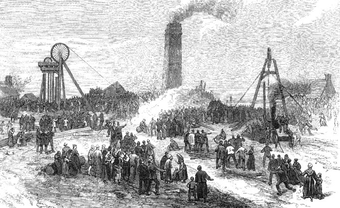
The accident at Pelsall
Colliery. From The Illustrated London News. |
|
It was thought that the trapped men
were in the shallow workings and that trapped air could
keep them alive. Large numbers of relatives and friends
waited at the pit head for news, and on the third day,
Sister Dora arrived from Walsall Cottage Hospital. She lived
with the waiting relatives, and distributed blankets and
food at the pit head. She did everything possible to
support and comfort them at that terrible time. Twenty
one bodies were eventually recovered, and were buried
together in Pelsall Churchyard, where there is a
memorial obelisk of Aberdeen granite. Unfortunately one
of the bodies, that of John Hubbard, was never
recovered, but the local community got together to raise
money to help the victim’s families, which included the
selling of specially printed memorial cards. A total of
£84 was raised. Hillside Crescent and Hill Wood, which
were built in the mid 1960s, now occupy much of the
colliery site.
There were two foundries in the
area, Yorkes Foundry on Lichfield Road which closed in
the early twentieth century, and Ernest Wilkes’ brass
and iron foundry in Mouse Hill, close to the canal,
which closed in 1978. The business was founded by Joseph
Wilkes in 1852. His son Ernest took over when he
retired. Joseph and his wife had six children before
moving to ‘The Sycamores’ in Church Road. Ernest
purchased a number of properties in 1917 when the
Charles family sold the Pelsall Hall Estate.
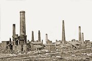
Pelsall’s best known heavy
industrial site was Pelsall Ironworks, which stood on
Wood Common, alongside the canal. The factory opened in
about 1832 and was owned by Wolverhampton banker,
Richard Fryer, along with several adjacent coalmines.
The ironworks gained a reputation for producing the best
quality bar and sheet iron.
Richard Fryer died in 1846, and
Boaz Bloomer, J.P. a prominent industrialist from Holly
Hall in Dudley, joined forces with Mr. Davis to form
Davis and Bloomer. They purchased the ironworks and
expanded the factory and the collieries. Boaz Bloomer’s
family had been in the iron trade for several
generations. He was born in 1801 and married Catherine
Hornblower, on 15th December 1825 at St. Thomas’s Church
in Dudley. They had eight children: Caleb, Boaz Jr.,
Esther, George, Giles, Prudence, Sarah and Benjamin.
Catherine died in 1849. Three years later, Boaz married
Emily Treffrey.
|
From Harrison, Harrod & Company's 1861
Directory and Gazetteer of Staffordshire.
|
In 1865 Boaz Bloomer purchased
Davis’s share of the company and began to run it with
his son, Boaz Jr. It became the Pelsall Coal and Iron
Company. By the 1870s, several hundred men worked there,
which caused a rapid rise in the local population. Many
of them moved to the Heath End and Pelsall Wood areas
with their families. A lot of the new employees had come
from the Ironbridge area. Coal was transported to the
factory by a network of tramways, and also from a canal
basin, next to Pelsall Ironworks. By 1872 there were
forty puddling furnaces, two blast furnaces, seven mills
and forges, a gas house with a gasometer, and limekilns.
The Pelsall Coal and Iron Company’s products were sold
throughout much of the world including Canada, China,
India, Norway, Sweden, and the United States.
Ironwork was hard physical labour,
and liquid refreshment was essential. Beer in buckets
was brought to the factory from the Free Trade Inn in
Wood Lane. The men were partly paid in tokens that had
to be exchanged for goods in the company’s ‘tommy shop’
in Wood Lane, near the canal bridge, where employees
could exchange tokens for goods at a lower cost than in
a regular shop.
Boaz Bloomer was a staunch Wesleyan
Methodist and a generous benefactor to the village. He
supplied the land for the building of the Wesleyan
Methodist Church in 1858, which stood in Chapel Street,
and largely funded its construction. When the church
opened on 14th July, 1859, he was made treasurer. His
son Ben Bloomer was church organist.
|
|
Boaz also contributed £750 towards
the building of the minister’s house and gave £1,000
towards the building of the Wesleyan day school in
Chapel Street in 1866, where he became Sunday School
Superintendent.
In the 1880s Chapel Street was developed
by the Bloomer family, who built houses for company
employees, near to the chapel and school.
|
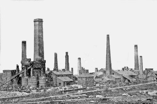
Pelsall Ironworks. |
|
The ironworks and the collieries
acquired a rail link to the London and North Western
Railway in 1865, and an interchange basin was built to
transfer coal from barges to the railway.
In the 1860s Boaz Bloomer opened a
reading room at the iron works in which newspapers and
periodicals were available for the employees to read. He
believed in the importance of education, and in the late
1860s introduced a scheme to help company employees pay
their children’s school fees. He soon made it a
condition of employment, that all employees’ children
had to go to school. In 1870, Boaz Bloomer and his
family had a large house built at 46 Church Road, called
‘The Sycamores’, which was later occupied by Ernest
Wilkes, a brass and iron founder.
Boaz built another large house in
the 1870s called ‘Riddings House’ which stood on the
corner of Wolverhampton Road and Wood Lane. In 1900 it
was owned by local mine owner John Starkey, and then
acquired in the 1920s by George Harrington, a local
baker. There were tennis courts in part of the grounds
that became the headquarters of the first Pelsall Lawn
Tennis Club. After lying empty for some time, the house
was demolished in the 1950s. The coachman’s house still
stands in Wood Lane. Boaz died in 1874 in Kensington,
Middlesex. After his death, his sons continued to run the business.
Boaz Bloomer Jr. lived in Grove
House, which was later occupied by Joseph Bullock,
Managing Director of the Pelsall Coal and Iron Company.
Groveside Way now stands on the site of the house.
The Pelsall Coal and Iron Company
remained profitable until the recession in the iron
trade in the 1880s. The factory began to open only one
week in every three, and by March 1891 it was
£3,647.11s.7d. in debt. In 1892 the bank demanded the
repayment of a £20,000 overdraft, which pushed the
company into liquidation. The collieries were sold to
the Walsall Wood Colliery Company, and Bilston
Steelworks bought much of the plant in the factory. The
buildings and chimneys on the site were demolished in
the 1920s when many locals came to watch the spectacle.
The site is now part of Pelsall North Common.
|
|
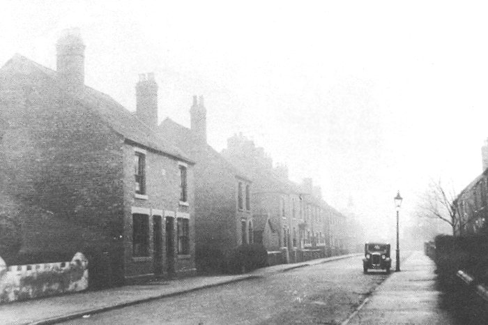
Chapel Street in the
1930s. From an old postcard. |
|
The Growing Village
The village became less isolated
with the coming of the railway in 1849, which changed
many people’s lives. The building of the South
Staffordshire Railway was authorised by an Act of
Parliament on 3rd August 1846 that allowed the
construction of a railway line from Dudley to Lichfield
via Walsall. It was designed by civil engineer,
John Robinson McClean, who
obtained a lease for the line on 5th August,
1850. He agreed to operate the line for 21 years from
1st August 1850.
The first
section between Bescot Junction and Walsall opened on
1st November, 1847, followed by the opening of the
section to Wichnor Junction, on the Midland Railway, on
9th April, 1849. The line started at Dudley and ran
through Wednesbury, Walsall, Rushall, Pelsall,
Brownhills, Hammerwich, Lichfield, and Alrewas, to
Wichnor Junction. The final section from Walsall to
Dudley Park opened 8th May 1850 and was extended to the
new railway station at Dudley in 1860. Pelsall Railway
Station was roughly half way along Station Road, near to
where the public footpath is today.
|
 |
| |
 |
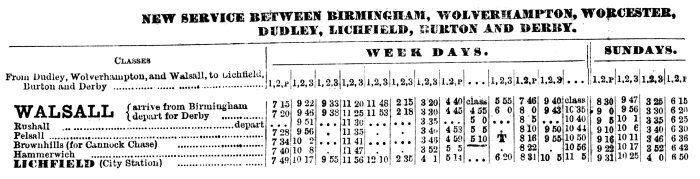
|
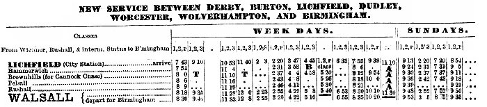
From the
London & North Western Railway's
timetable, August 1874. |
|
|
In
1861 the lease for the South Staffordshire
Railway was transferred
to the London and North Western Railway Company,
who then operated the line. The company took it over on 15th
July, 1867 and it became part of the London and North
Western Railway. As the local coalfields closed, the
pits at Cannock responded to increased demand and so Highbridge and Ryders Hayes Junction became a
marshalling yard for coal trucks from the Cannock pits.
By the 1920s and 1930s the junction had become extremely
busy and so was a prime target in World War 2 for German
bombers, in an attempt to cripple coal supplies to
Birmingham and Coventry. They were attacked in a bombing
raid, but the bombs missed their target and destroyed a
house in Highbridge Row. Luckily there were no injuries.
The Row was demolished in 1964.
Brownhills Railway Station
closed in 1965 as a result of the Beeching Report,
although the line continued to be used for goods until 1983.
The track bed is still in use today, for leisure. In
2000 the section from Walsall to Pelsall became part of
the Sustrans National Cycle Route and in 2018 it became
part of the 'McClean Way' named after John Robinson
McClean.
|
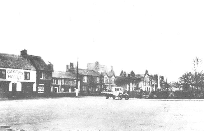
|
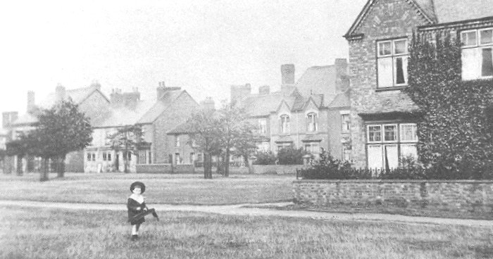
Looking towards Station
Road in the early 20th century. From an old
postcard. |
|
As the population increased in
the 1860s, affordable houses were built at Heath End and
in Wood Lane, and the first shops were built in Norton
Road, which supplied the villagers with their every day
needs, including food, clothing, and household goods.
The wealthier members of society had houses built in
Chapel Place (now Chapel Street) and later in Ashtree
Road.
In the 1860s and 1870s Heath End
rapidly grew due to the establishment of a brickworks
and two collieries in the area. This led to the building
of back to back terraces around Princess Street that
stood between Walsall Road and Victor Street. They
suffered from poor sanitation and a crude water supply,
having just a single communal tap that supplied water to
20 or 30 houses.
The population of Pelsall in 1851
was 1,132, which had grown to 2,928 in 1881. Around
1885, Miss Hussey of Wyrley Grove opened a free lending
library and a night school in Highbridge (now Lichfield
Road) and closed the Railway Colliery Hotel. She had it
converted into houses and improved the adjacent
buildings.
By the 1890s, Pelsall’s shopping area was
well developed. The 1891 census lists the following
shopkeepers and their shops in Norton Road:
William Clark, grocer; William
Gilbert, butcher; Ernest Haldane, draper; James
Harrison, hairdresser; Richard Lane, greengrocer; Moses
Palmer, tailor; Edward Sluter, the postmaster; Harry
Smith, druggist; Edward Trimingham, chemist; and Joseph
Williams, stationer and picture framer.
By 1891 the local population had
grown to 3,364. Pelsall Parish Council was formed in
1894, and three years later took over the care of the
common land. By the end of the century the village had
become almost self-sufficient; with its local council,
shops and amenities, and an identity of its own.
|
|
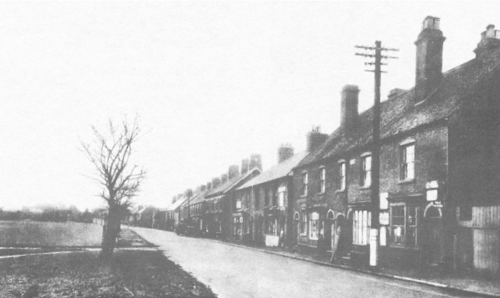
Norton Road. From an old
postcard. |
|
Churches and Chapels
The earliest known church in the village was in
Paradise Lane, near to Pelsall Hall. The church, known
as St. Peter’s, had an area of land that was farmed to
fund a priest. The land had been given to the church by
William de Keu in 1311. During the short reign of King
Edward VI (1547-1553), an attempt was made to introduce
the Protestant faith to England, based on churches in
Switzerland and Germany. During the campaign, churches
were inspected to determine the value of property and
goods, and Catholic trappings were taken away. When
Pelsall church was inspected, the plate and vestments
were removed by Richard Forsett, and only the two church
bells in the steeple were left.
The roof of St. Peter’s Church collapsed in 1762, and
in 1763 the church was rededicated to St. Michael and
All Angels. On the 7th November of that year, the first
burial took place in the new graveyard next to the
church in Paradise Lane. The first person to be buried
there was Edward Wiggin. The old graveyard can still be
seen today, next to Pelsall Hall. The site has been
tidied and grassed-over, but a few of the old headstones
have survived. They have been placed against
the brick wall on the left-hand side of the site, next
to the drive that leads to the hall. Stebbing Shaw
describes the church as 'small and ancient' in his
'History and Antiquities of Staffordshire' published in
1801. The half-timbered vicarage was further along
Paradise Lane and had a thatched roof.
The church could only seat 174
people and so was too small to cope with the growing
population. The decision was taken to build a larger
church in the village that could seat around 600 people.
The foundation stone for the new church in Hall Lane was
laid on 7th June, 1843 and building work was completed
in the following year. The new St. Michael and All
Angels Church was built of plain brick, and initially
had no tower. When the church opened, the old church in
Paradise Lane was demolished. The church tower, built
some years later, was a gift from Mrs. Sarah Dickenson,
who provided the clock and a peal of five bells. A sixth
bell, added in 1920 was a gift from Mrs. J. S. Charles.
In 1848 a vicarage was added at a cost of £1,000, but
this fell into a state of disrepair and was demolished
in 1980. The chancel was added in 1889 and a new organ
was installed.
The first Methodist chapel in the
village opened at Heath End in 1830. It was replaced by
a new building in 1869, but was never a great success.
The trustees were often faced with bills from costly
repairs, especially in 1905-6 when the cost of
renovation work amounted to £103.13s.10½d., a
considerable sum at the time. A pipe organ was also
installed at a cost of £50. The congregation dwindled in
the late 1940s when the old houses at Heath End were
demolished and the people were re-housed elsewhere. The
chapel closed in 1959 and was soon demolished.
In 1836 another Methodist chapel
opened in Station Road, after a petition had been sent
to the local authority, stating that although the local
population was rapidly increasing due to the growth of
ironworks and collieries, there was no provision for
education. If permission could be granted for the
building of a chapel, a school for children of all
denominations would also be built on the site.
Joseph Fletcher, an inspector of
schools was sent to Pelsall to investigate, and reported
that due to the poverty of the poor nail makers and
miner population of this remote neighbourhood, nothing
but extraneous aid will ever meet their case. Thanks to
his report, permission was given for the building of the
chapel and a school, which were built for £260. In 1858
the school came under Government control and received
its first certified teacher in January 1859. The
Wesleyan chapel and the school were a great success, so
much so that they couldn’t cope with the demand.
|
|
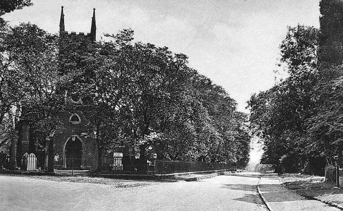
St. Michael and All Angels Church
in Hall Lane. From an old postcard. |
|
A larger Wesleyan Methodist chapel
opened in Chapel Place (now Chapel Street), on 14th
July, 1858. It was largely funded by Boaz Bloomer who
ran the Pelsall Coal and Iron Company. He supplied the
land on which the church was built and contributed £750
towards the building of the minister’s house. He was
made church treasurer, and his son, Ben Bloomer, was
church organist.
Boaz Bloomer also gave £1,000
towards the building of the replacement school, which
opened in 1866 in Chapel Street. Boaz became Sunday
School Superintendent. The school was enlarged in 1895
and continued as a day school until the mid 1960s.
The chapel was renovated in 1904 at
a cost of £660, and survived until demolition in 1970.
By this time the chapel had taken over the old Wesleyan day school and
amalgamated with the worshipers from the Primitive
Methodist Chapel in Paradise Lane, which had opened in
1853. A large extension was added to the church in 1970,
which is now known as Pelsall Methodist Church.
The old chapel in Station Road,
became known as Central Hall and remained in use as a
community centre. The Mutual Improvement Society had a
reading room in the building, and the Wesley Guild, the
Pelsall United Friendly Society, and the Parish Council
held meetings there. In 1923 a concert and a billiards
room opened in an extension at the back of the building,
and the hall became the headquarters of the local A.R.P.
wardens in the Second World War. It has now been
demolished.
Education
Some of the older inhabitants
remembered a Dame School and a Poor School in the
village that charged 4d and 1d per week, respectively,
for lessons. Although the Employment Act of 1842
prohibited children under 10 years of age, from working
in the mines, many families could not afford the education
fees.
In 1845 St. Michael and All Angels
Church applied to the National Society for a grant
towards the building of a National School, which could
cater for 133 pupils, with a residence for a master. A
site for the school was provided next to the graveyard.
The estimated cost of the school was £432.4s.7d., which
included the £95 grant from the National Society and
£110 that was given locally. Pelsall National School
opened in about 1848. In 1865 there were 180 pupils
being taught in one room by a master and a mistress.
Large numbers of children started at the school from the
age of three, which led to an acute shortage of
accommodation. In 1870 the room was divided into two
smaller rooms by sliding doors.
In 1881, after the passing of the
1880 Education Act, which led to compulsory education
for 5 to 13 year olds, a new boys’ school was built
alongside the existing premises to accommodate 230
pupils. Free schooling did not happen in the village
until 1891, before which, a two pence a week fee was
charged for each pupil. Another room was added in 1891,
and in 1895 there were 395 pupils. In 1907 the school
became Pelsall Church of England School.
In 1916 the infants were moved to a
new council school in School Lane and in 1931 the
original school building was demolished to make way for
a new infants block. In December 1965 most of the staff
and pupils moved to the new school that opened in Maple
Road in 1961. The old school continued in use as an
annexe until 14th December, 1977.
|
|
Station Road. From an old
postcard. |
|
Into the Twentieth Century
In 1901 the population was 3,626
and more shops opened, in order to keep pace with
growing demand. In High Street in 1908 the shops were
occupied by shoe makers, bakers, a grocer, a tailor, and
a beer seller. In 1909 gas mains were laid in the
village, and in 1924 electricity cables were added. The
village’s first regular bus service to and from Walsall
began operating in 1925, and in 1934 Pelsall came under
the control of Aldridge Urban District Council.
|
|
The Swan Inn, Wolverhampton
Road. |
By the 1950s there were many
run-down and dilapidated houses in the village and so
the local authority started a slum clearance programme.
In 1952 Pound House in Paradise Lane was demolished. It
stood next to the village pound where the stray animals
were kept. Other demolitions at the time included the
old chapel, the old vicarage, and Paradise House in
Paradise Lane, which had been a large house with a
picture of Adam & Eve above the front door. Another
casualty was a row of terraced houses known as Slate
Row, in Church Road. They had once been occupied by nail
makers, ironworkers and miners, and in 1895 a resident
died from typhoid. There were also several cases of diphtheria.
Another casualty was Pelsall Farm,
a large three storey building off Charles Crescent with
a cottage attached. It had twelve acres of land,
including meadows and two ponds with ducks and geese.
In
1952 the council purchased the estate from Mrs Wallace
of Little Wyrley Hall for £2,000 and rented the land to
a local farmer.
In 1964 the site was redeveloped for
housing and Charles Crescent was built on part of the
site. |
|
Oaklands House was a large house in
Station Road that had been owned by the Binns family,
and previously by Thomas Starkey, when it was known as
Victoria House. In 1956 Aldridge Urban District Council
purchased the house and grounds for £3,000. The grounds
were sold for redevelopment in 1962 and the house was
demolished and replaced with the Pelsall Community
Centre building, which is there today. The Pelsall
Community Association, which is based at the community
centre, was formed on 1st July, 1946 to serve the local
community. The community centre was officially opened by
Sir Alfred Owen, CBE. on 4th September, 1965. In 1974
the building was extended when the Oaklands Lounge & Bar
were added. Activities at the centre include adult dance
sessions, keep fit classes, Taekwando, ladies'
kickboxing, art classes, embroidery classes, and mother
and toddler sessions. The site includes a bowling green
and tennis courts.
There were several working farms in
the area until the late 1940s, but most of the land has
now been used for housing development. In the 1960s a
large number of council houses were built on the Ryders
Hayes Estate between Ryders Hayes Lane and Railswood
Drive, and in 1970 much of the old housing and the New
Inns pub near the end of the old Gilpin Arm were
demolished and replaced by the modern estate. The pub
began life as a beer shop and afterwards became the
headquarters of the local pigeon flying club. By 1940 it
had become a general store.
In 1966 Pelsall became part of
Aldridge and Brownhills Urban District Council, and on
1st April, 1974 it became part of Walsall Metropolitan
Borough Council, which was formed following a local
government reorganisation.
The old fingerpost at the junction
of Norton Road and Lichfield Road still remains, after
being restored in the 1980s by Bert Kellitt, for the
local Civic Society. Pelsall also has a Millennium
Stone, marking the 1994 millennium of the village. Since
July 1972 Pelsall has had an annual carnival which was
originally a week-long event. It is very popular and
features decorated floats, many outdoor events on the
common and indoor events at the community centre.
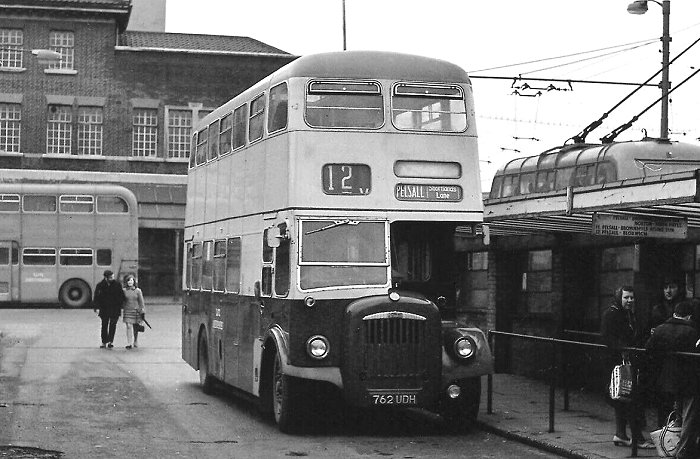
The Pelsall bus in the old Walsall
bus station.
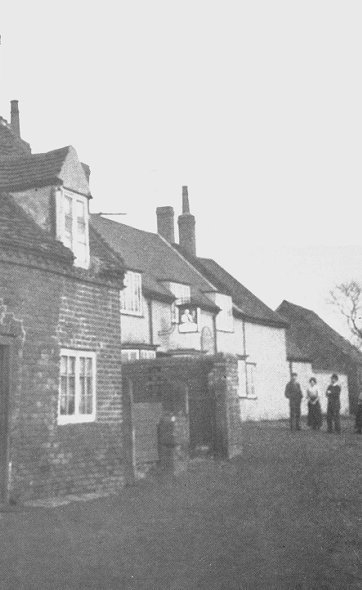
The main shopping area around Norton Road and High
Street continues to thrive. There are card and gift
shops, dry cleaners, estate agents, fish and chip shops,
flower shops, food shops, hairdressers, The Queens pub,
and much more.
The population is now over 11,000. It is listed as
11,505 in the 2011 census. A valuable asset to the local
people is Pelsall Village Centre, in Highfield Road,
which opened in 2012. Sadly Pelsall Library which was based
there, closed in 2017 as part of Walsall Council’s
cost-cutting plans. Luckily a team of volunteers now run
the Pelsall Book Exchange there, where people can sit in
comfort to read books, or borrow them.
Pelsall is still a very pleasant
place to live, partly because the open areas have been
well protected and preserved over the years. The North
Common Local Nature Reserve is an important asset,
consisting of wet heathland and a wonderful variety of
wildlife from butterflies and bees, to many species of
birds and mammals.
|
 |
Return to
the
previous page |
|