| Beginnings
Wednesbury lies between Wolverhampton and Birmingham, in
the upper Tame valley, on the thick Carboniferous coal
measures around Church Hill.
Little is known about the origins
of the town or its early years before the Norman
invasion. No evidence of early colonisation has been
found. Reeves, in his “History of West Bromwich”
mentions that a number of Roman coins from the first
century were discovered at Wednesbury in 1817. The find
included coins from the reign of Nero, Vespasian, and
Trajan. Another Roman coin was found at Wood Green
during the excavation of the railway cutting, and a
piece of Roman glass came to light in Monway Field.
There is no evidence of Roman occupation in the area, or
any evidence of Roman roads.
Legend has it that Church Hill was
fortified by King Alfred’s daughter Ethelfleda as part
of her struggle to defeat the invading Vikings in the
10th
century. Although she built 10 fortresses in the Kingdom
of Mercia for the purpose, no evidence of an early
fortification has been found at Wednesbury.
The earliest recorded reference to
the town appears in the Domesday Book of 1086 and this
gives an insight into the initial colonisation of the
area. Wednesbury is recorded as Wadnesberie. The first
part of the name (Wadnes) refers to Woden the Saxon’s
god of war, and the second part (berie) is derived from
the old English byrig, meaning a burgh, or burh, which
is a fort. So the derivation of Wednesbury appears to be
Woden’s fort. Woden place names usually indicate holy
ground, and as the cult of Woden, both on the continent
and in England was often connected with hills, a shrine
or temple could have been built on Church Hill.
The god Woden continued to be
worshipped until the spread of Christianity, which
reached this part of the country around the middle of
the 7th century. This suggests that the site
was colonised before then.
Central England was thickly wooded
and so the Saxons penetrated the area via the Trent
Valley and the Tame Valley; Tame meaning the dark river.
Old place names are often a source of evidence,
referring to long lost features of the landscape.
Unfortunately few such place names can be found in the
area, but there is one exception, Ridding Lane. When the
area was originally colonised, the trees would have been
cleared to make way for the settlement, and the fields
on which to grow crops and graze animals. The name
Ridding possibly refers to the original clearing by the
stream, at the time of the settlement.
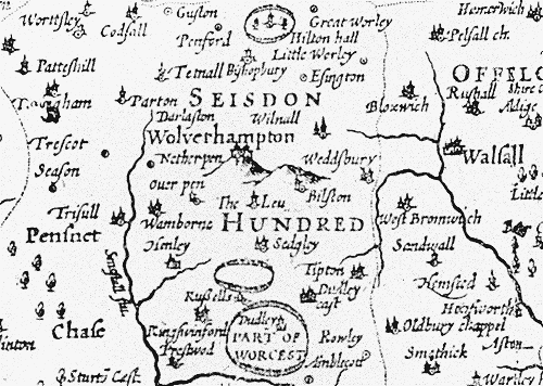
Part of a map of Staffordshire
from 1610.
Domesday
The entry for Wednesbury in the
Domesday Book provides us with the earliest information
about the town. Although the Norman rulers spoke French,
the official language at the time was Latin, and the
translation for the town’s entry is as follows:
The King
holds Wednesbury with its appurtenances. There are 3
hides. There is land for 9 ploughs. There is 1 plough in
the demesne with 1 slave. And there are 16 villeins and
11 bordars with 7 ploughs. There is a mill worth two
shillings. And 1 acre of meadow. There is a wood 2
leagues long and 1 wide.
Bloxwich is a
member of the same manor. There is a wood 3 furlongs
wide and 1 wide. And in Shelfield there is 1 hide which
is waste. It belongs to the same manor.
The entry tells us that the land
belonged to the King and that at the time both Bloxwich
and Shelfield were part of the town. Wednesbury had 3
hides; a hide being a piece of land large enough to
support one family, or as much land as could be ploughed
with a team of 8 oxen in a year. A hide usually covered
about 120 acres. About twice as much uncultivated
farmland was available; as there was enough land for 9
ploughs. Another hide is listed in Shelfield and is
described as waste. This means that for some reason no
tax could be collected from it.
The entry also states that there
was 1 plough and 1 slave in the town, both belonging to
the King. With the plough would have been a team of
oxen, usually eight in number. As the slave and plough
are grouped together, the slave was probably the man who
ploughed the fields.
The entry goes on to list 16
villeins and 11 bordars with 7 ploughs. Villeins were
the better off peasants whose land and possessions
belonged to the lord of the manor. They were not free to
leave the manor, and they were subject to a large number
of obligations required by the lord, including work on
the lord's land for two or three days a week, additional
work at harvest, and the payment of manorial dues. They
also had to pay for the right to brew ale, bake bread,
and grind corn at the lord's mill. Villeins usually
cultivated between 20 and 40 acres of land, often in
isolated strips. Bordars had the same obligations to the
lord of the manor as the villeins. They had little or no
land, and usually lived in a cottage on the edge of the
manor. Most people at the time were from this class and
were lower in the status than the villeins. It is
believed that the people listed were in fact the heads
of households, and so modern historians tend to multiply
the total by 5 to roughly estimate the actual
population. The rough calculation suggests that there
were around 140 inhabitants at the time.
A mill is mentioned that was worth
2 shillings a year. This would have been one of the
smaller corn mills, the average mill being worth between
2 shillings and 5 shillings. At this time all mills were
water powered and so it would have stood by the River
Tame. In 1286 the mill was recorded as standing by
Finchpath Bridge, which crossed the river close to where
Hydes Road crosses it today. On average there was one
mill for every 46.7 households in the county, and as
Wednesbury had a maximum of 27 households, it is
possible that the mill also ground for neighbouring
villages and hamlets.
From the above information it is
possible to get some idea of Wednesbury’s importance in
the local area by comparing it with some of the
neighbouring towns.
|
Town |
Estimated
population |
Number of
plough teams |
|
Aldridge |
35 |
4 |
|
Aston |
220 |
18 |
|
Bilston |
55 |
3 |
|
Birmingham |
45 |
3 |
|
Bradley |
20 |
1 |
|
Cradley Heath |
75 |
7 |
|
Dudley |
80 |
11 |
|
Halesowen |
350 |
46.5 |
|
Rowley Regis |
345 |
34 |
|
Sutton Coldfield |
130 |
8 |
|
Wednesbury |
140 |
8 |
|
West Bromwich |
65 |
4 |
|
Willenhall |
80 |
6 |
|
Wolverhampton |
250 |
20 |
From the table it can be seen that
Wednesbury was one of the larger towns in the area, the
largest being Halesowen. It seems that Wednesbury was a
typical small country village, housing a farming
community living in small cottages, with a water-powered
corn mill by the river. |