A preliminary
|
|
A preliminary
|
|
Earliest times Blakenhall does not have an exactly defined area. Perhaps the nearest we have is the Blakenhall ward of the council. I am taking it as being approximately the area bounded by Goldthorn Hill, Penn Road, Dudley Road and the Ring road. This area consists of ground sloping steeply to Goldthorn Hill in the south and towards the Penn Road in the west. To the north and west the ground is flatter. There must once have been one or more visible streams providing drainage and water for the local farms; but these are no longer apparent and only make one, somewhat uncertain, appearance on the maps, with what may be a stream flowing south-east to north-west, very roughly along a line including Fellows Street. When this page was first put on this web site I wrote:
Since then David Horovitz has published his "Place Names of Staffordshire", from which it appears that "halh" does not refer to a building but is a very generalised word with no more specific meaning than "a place". The element "black" derives from "blaec" meaning "dark coloured". I would speculate that it must meaning something like "the place with dark coloured (earth?)"; and that the name suggests that this area of land was not the centre of a landholding but an outlying part of some estate or other. The land here would have been forested, though probably not very heavily. The many place names around Wolverhampton ending in –ley reflect the forest clearings. (The other, apparently contradictory, meaning of "ley" is a wood in an unwooded area. But it is reasonable to suppose that this area, like probably all of the land around Wolverhampton, was wooded and all the -ley names refer to clearings). The area contains Ablow Street, which refers to the medieval Ablow Field. The place name element "low" usually refers to a tumulus and one has been recorded in this area and has been said to lie below St. Paul's church, which used to stand between Sunbeamland and the Penn Road. All this suggests that there was settlement in the area from Anglo-Saxon times and even back into pre-historic times. Presumably, after the Conquest, the Blakenhall area was within one of the Wolverhampton manors. Certainly it would have been gradually cleared and farmed (and very lightly populated). At least some of the Blakenhall area was within Wolverhampton’s open field system. Wolverhampton had five open fields, given by Mander as:
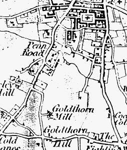
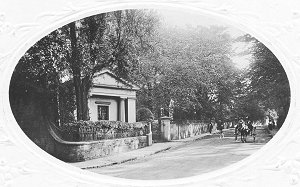
The extent of these fields is not known but it seems, from Mander’s description, that Ablow Field would have run across the northern part of Blakenhall, to meet Monmore Field to the east. Mander says that "In the years 1587-9 we have clear evidence of the break up of the ancient open fields and their consolidation into farms". Presumably therefore it started somewhat before that time and continued thereafter and Ablow Field would have been enclosed (by agreement) around this time. The area outside the open field may well not have been common land but fields held in severalty as the result of assarting. Maps of the fields, before they were built on, look mostly like early enclosure by agreement. Certainly there never was an Act for their enclosure. (The Act for enclosing Tettenhall Wood is the only one in this whole area). We do not have any names of people or estates in this area at this time. The nearest are the Ridleys at Graiseley, whose estate seems to have been mainly, but not wholly, on the western side of the Penn Road; and the Leas, after whom, or whose farm, Lea Road was named, were in the same area. We can be sure that Penn Road and Dudley Road are early roads, which would have come into existence as Wolverhampton became a religious and market centre. The road over Goldthorn Hill seems similarly ancient. There are still one or two old buildings on the line of that road. The exact function of that road is not clear.
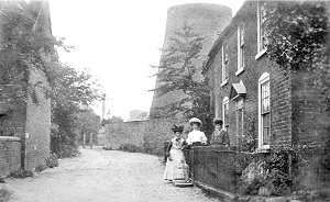
Blakenhall and its area get very little mention in our histories. Nothing much happened there. No great men lived there. Small farmers and their labourers followed the agricultural round of the year. The windmill just off what is now Goldthorn Road survived into the present century as a reminder of this agricultural past. The coming of housing and industry What changed Blakenhall was the growth of Wolverhampton. This large market town had expanded mainly in an east-west direction, avoiding the steep hill where Darlington Street now is and the low and marshy ground towards Tettenhall. The metal bashing industries of Wolverhampton expanded beyond agricultural blacksmithing in the 1600s but the town did not extend much, physically, until the mid-1700s. On Isaac Taylor’s map there are many signs of expansion – but St. John’s is as near as it had got in the direction of Blakenhall.
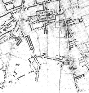
The great surge in industry which occurred in the 1800s brought development past St. John’s and towards Blakenhall but not far into it. The 1834 map shows a road, which seems to be on the line of Powlett Street, with a little development along it. Most of the population increase in Wolverhampton was accommodated by increased crowding within the old, established area. The 1850 map shows a similar state of affairs but with indications of some development along the Dudley Road frontage; and with two large ponds shown in the vicinity of what is now Pool Street. The two maps also show what seems to be the start of Villiers Street.
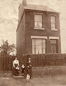
It is not until after 1850 that a lot of Blakenhall fell to the developers. This expansion was a mixture of factories and housing (with the housing nearer the centre often later falling prey to industrial uses and demolition).
This triangle of land fell to the developers for a number of reasons. It was handy enough for the factories and other workplaces and did not involve the development problems there would have been to the east of the Dudley Road – that area lay to the east of the fault which defined the land which contained coal, ironstone, limestone and brick clay. At this time it was either in active mining or industrial use or was derelict as a result of such uses. To the west, a number of gentleman’s houses had been built along the road – and they would not have liked too much development near them – and the land was still held in the Graisley Old Hall estate.
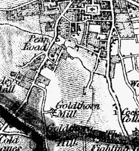
It may be that whoever were the owners of the fields which now lie under Blakenhall, they were willing to sell but anxious to retain a consolidated farming unit. The map of 1901 clearly shows such a farm unit between Penn Road and Villiers Street. To the north much of the area was owned by the Duke of Cleveland, who owned a lot of land in and around Wolverhampton. He is said to have been a reluctant seller of his land and to have cramped Wolverhampton’s development. I am not at all sure that is the case. Anyway he sold the land on which Fellows Street and the Recreation Ground were built. To the south there were also a few large houses on Goldthorn Hill, including the homes of Sir Alfred Hickman and Joseph Sankey. |
|
|
Return to |
Proceed
to the |