A preliminary
|
|
A preliminary
|
|
|
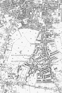
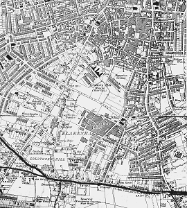
Into the twentieth century The area was developing at much the same time as New Hampton was being developed to the northwest of the town centre. But New Hampton was created more or less in one fell swoop under the aegis of the Borough Council. Blakenhall developed over a much longer period of time and its development followed the same general pattern as most other places. In general development took place nearest the town centre first but which land was developed depended on what landowners were prepared to sell; and what developers thought they could sell on any particular plot of land. There is some evidence that Fellows Street and it vicinity were intended, by the owner, Lord Barnard, to be laid out and developed as an estate. But generally development was sporadic, with builders buying one or a few plots and developing them speculatively. So the style and standard of housing varied from street to street and within streets. This housing development could be broadly dated by examination of maps and by a walking survey of the remaining stock – which seems to be most of it. Such a survey could also classify the standard of housing (from the terraces in the northern part to the small villas of the southern part, the standard of which is indicated not only by their size bit also by such architectural embellishments as the tiled porches).
Which land was developed, and how, was in part dependant on distance from the site to places of employment; and on transport – especially tram, bus and trolley routes – which were also dependant on what land had been developed. A study of these routes (mainly from the books of David Harvey and John Hughes) might be revealing. The progress of development can also be traced through some of the buildings to which dates can be ascribed.
Peter Hickman’s history of Nonconformists in the area also gives indications of the course of development. There is some evidence in that work to suggest that there was more than a small agricultural population in the area from the beginning of the 19th century. The building of their churches or chapels can be listed here:
Most of these congregations eventually came together in St. John’s, Parkfields. Schools seem to have come late – as they did elsewhere. The only ones I have noted are:
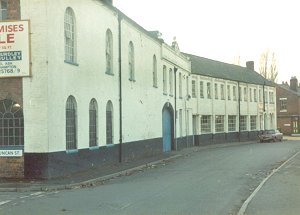
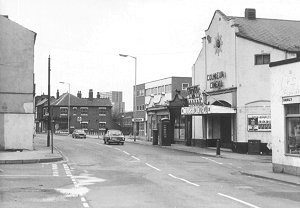
Shops appeared, often in the front rooms of houses, but some purpose built, especially on Dudley Road. Pubs, by this time, were usually purpose built, rather than being in the front rooms of houses. Clubs also appeared. Pubs and clubs were social centres, and centres for sports. And in perhaps only one case, land was set aside for recreational use: the Recreation Ground at Fellows Street. But sports of many kinds must have been an important part of the social life of the area. There seem to have been several bowling greens around and Angeline Johnson’s story of the Powell Family provides evidence of the one at the Conservative Club in Baggott Street. Of course the Fighting Cocks provides evidence of earlier and ruder sports but it was in that area, and at St Luke’s church, that Wolverhampton Wanderers find their origins. Wanderers Avenue remembers, in its name, one of their famous victories, but by that time they had moved their ground from near the Fighting Cocks to the present site behind the Molineux Hotel. (Note: Sir Alfred Hickman lived on Goldthorn Hill and is said to have been the Wanderers first President. Wolves’ present ground is always said to have been built on the grounds of the Molineux Hotel but it is the Hickman family tradition that their family provided at least part of the ground). Also Wolves was formed by an amalgamation of a football club and a local cricket club; and that is evidence of another sport in the area. The City Archives contain a reference to the Blakenhall Angling Club too. Industrial development took place mainly in the northern part of the area, nearest to the city centre but the Niphon Works on Villiers Street is a remarkable exception. It seems to have been built, all of a piece, in about 1875. It was well away from the traditional manufacturing area and was very much bigger than anything else around at the time. It does not seem to have lead to other industrial development taking place in the immediate area. Through the twentieth century As late as 1900, and even up until the first world war, there were still plenty of fields around. They eventually got taken up by factories, such as Sunbeam, Villiers and AJS; or by the inter-war housing estates. These developments, and the new roads they required, notably Marston Road, are clearly seen on the 1920 O.S. Map. In 1912 Blakenhall’s only cinema opened – the Coliseum, on Dudley Road. It has a very interesting history, reflecting the changing times, it being used from 1963 to its closure in 1980 for showing Indian films. (Ned Williams, Cinemas of the Black Country, has a full history and a photo).
Blakenhall, seen as a separate entity, would always have had a population of incomers, and I would guess that, from the start of the area’s expansion, not many of them came from Wolverhampton, except intermediately. Originally the houses were for those who were doing all right, mostly through factory work, either on the shop floor or in management; and also, of course, people in service industries.
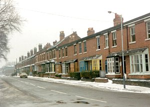
Blakenhall was mainly an area of private housing. The council houses in Green Lane (which is just about within this area) were claimed to be the first council houses opened in England. Other than that there was no council housing in the area – probably because there was not any land available for the purpose. The area did not come under any slum clearance scheme in the 1920s and 30s, presumably because there were no sizable pockets of sub-standard housing. In the post war period there was no room for temporary housing (such as prefabs) and, in any event, it seems that no bombs fell on the area. The post-war slum clearance schemes seem to have missed the area and it was only at the end of such schemes that the Baggott Street area was caught.
But in 1964 the area did get one of the tower block schemes that were popular at the time. The Blakenhall Gardens scheme was for 580 flats, a multi-storey car park, tenants workshops, meeting rooms and other facilities, The contract, for £2,126,475, was given to Watts (Midlands) Ltd.. Film exists of the building of these flats, which includes the children of St. Luke’s following the construction process, and the opening by Sir Keith Joseph.
As the private housing got older and the first occupiers improved themselves and left, the area went down in status – and rentable value. It became a typical place where incomers, who had come looking for jobs and who, by definition, had little or no money, would first settle. In our case this happened very noticeably in the years after the second world war. It was, therefore, happening at a time when slum clearance was all the rage and tower blocks were seen as an important part of the solution to the re-housing problem. It was not until the mid-60s that the government decided that most slums had been cleared and that what was now needed was improvement of the existing stock. So we got housing action areas, priority neighbourhoods and the like. Then Wolverhampton followed another national trend when manufacturing industry collapsed very suddenly. Areas where people had depended heavily on jobs in those industries suffered greatly and so did Blakenhall. Whilst the post-industrial society has, in the last ten to twenty years put many people and many areas of the city back on their feet, this has almost by-passed Blakenhall and its All Saints’ neighbours. |
|
|
Return to |
Return to
the |