 |
North Street |
 |
| North Street was previously called Tup Street
which is a reminder of the wool trade that originally made the town so
prosperous. Tup Street ran along the western edge of the town next to Broad
Meadow which consisted of open fields right across to Tettenhall. The
southern part of the street was dominated by church properties as it mainly
consisted of a row of houses that were occupied by the prebendaries. In the
18th century the town's prison was situated here, on what is now the car
park facing the front of Giffard House.
The conditions there left a lot to
be desired as it was unhygienic and not very secure. It was demolished in
about 1820. In the 17th and 18th centuries the northern half of the street
was slowly transformed as it filled with small cottages. By the late
nineteenth century the whole area was very run-down and so the cottages were
replaced with the houses shown below. |

|
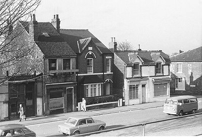
North Street in April 1974. The cobbler's shop on the
corner belonged to Mr. G. O'Connor and hardly changed during its entire
life.
I visited the shop a few weeks before its final closure. It was a
delight to see the original Victorian interior still intact and also to
hear that it was to be given to the Black Country Museum for
preservation. |
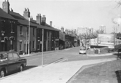
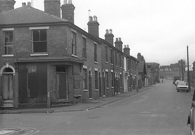
| This view taken in January 1974 is typical of the area.
The road on the right is Deanery Row and off to its left was Nursery
Walk which ran parallel to North Street. The first shop on the
left was McGovern's barber's which survived for many years.
The shop was
on the corner of Vincent Street, which ran into Molineux Street
immediately opposite the football ground. |
|

|
The View from Nursery Walk looking towards Vincent
Street. McGovern's barber's shop can again be seen on the left, the shop
on the right was a general stores.
The steps on the left led up to
Nursery Walk and Nursery Street.
The football club floodlights and the
top of the Tarmac building can be seen in the distance. |
| Nursery Street as seen from North Street. The building
on the far left was the premises of Harrington Sign Writers.
Sid
Harrington himself lived on the opposite side of the street.
He was a
champion weight lifter who took part in the Olympic Games. |

|
|
Another view of North Street taken from Nursery Walk in
January 1974.
On the immediate left is a blacksmith's yard and shop.
The
shop to its right on the corner of Dawson Street was a newsagent's. They
also sold tobacco, cigarettes, sweets and toys. |
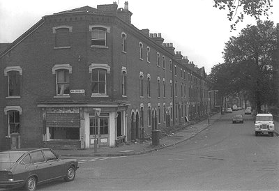
| This photograph taken at the same time and place as the
previous one looks a little further down the street. The newsagent's and
Dawson Street are on the immediate left.
The shop on the right hand
corner of Dawson Street was a butcher's and to its right is a
greengrocer's, a hairdresser's and Piggotts newsagent's.
In those days
much of the weekly shopping could be carried out in North Street itself. |

|

|
Looking up North Street towards town. The factory
building on the right, on the corner of Birchfield Street, was
occupied by Mayes electrical engineers. It was demolished in January
1976. Until 1961 the building was a lock works owned by Albert Marston
and Company, whose main products were door locks, stock locks and lever
cylinder night latches. |
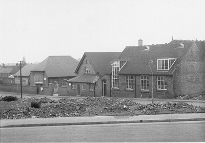
| Birchfield Street seen from North Street, just after the Mayes
building had been demolished. The buildings are the rear part of
Red Cross Street School.
The large building on the left is part of the
infants school and in the middle is the assembly hall. The junior school
is to its right. |
|
|
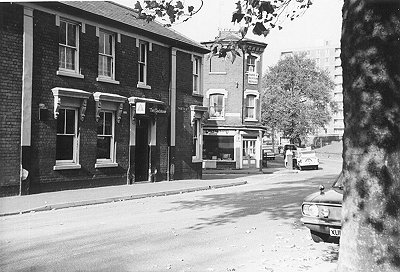
The top of North Street. On the left is the Gladstone
Pub and to its right is Red Cross Street, directly ahead is North Road.
The shop on the Corner is Chappell Radio which sold television's and
radio's.
For many years it was a wool shop and haberdashery that was run
by Mr and Mrs Corkindale. |
| Looking up Red Cross Street towards North Street. The
street on the left is Edward Street and the shop on the corner was a
greengrocer's.
The white building in the middle is an off licence, and
the building with the low roof is Red Cross Street Chapel.
To its
immediate right is Red Cross Street garage. Just out of sight on the
right is Red Cross Street School. |
|
|
Looking up North Road from the end of North Street.
On
the left is Red Cross Street with Chappell Radio on the corner.
The row
of houses was called Gladstone Terrace. |
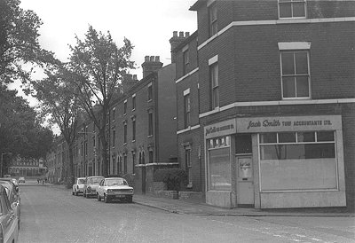
| Looking back along North Road towards North Street.
The
street on the immediate right is Oxley Lane.
The corner shop is Jack
Smith Turf Accountants Ltd which used to be a Co op. |
 |
Acknowledgement
I would like to thank John Harris for all of his help on this section.
 |
|
|
|
|
Return to the
Civic Centre |
|
Return to the
beginning |
|
Proceed to
Horseley Fields |
|