|
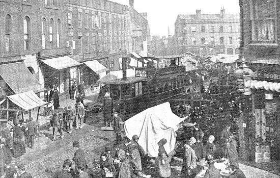
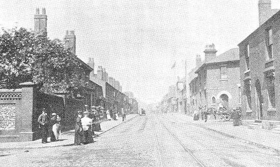
Wednesbury Market. |
This view of the Market Place was taken from Five Ways
before the installation of electric traction for the
tramways in 1892. A steam tramcar is coming through the
market. Abreast of the engine, a group of colliers is seen
returning from work, while in the middle foreground may also
be seen a number of pit bank girls. The market is open on
Fridays from five a.m. to eight p.m., and on Saturdays from
six a.m. to eleven p.m. |
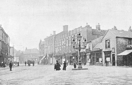
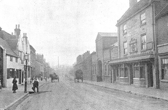
| This view has been taken from the lower end of the
Market Place. The electric wires of the tramway are seen on
the left. It is characteristic of Wednesbury that so few
people are to be seen in the streets in the daytime, for
being essentially a working man's town everybody is at work
during the middle of the day, and the streets only become
lively in the evening after factory hours are over. A coal
cart is here the only evidence of vehicular traffic. |
The Market Place. |
|
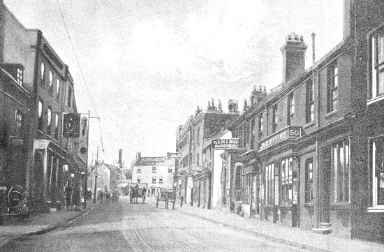
Lower High Street. |
Looking up into Market Place, where are
now seen the Old Market Cross Inn and Richards' pawnshop, a
view which in olden times was obstructed by the
Market Cross, demolished in 1824.
On the left of the Lower High Street is seen the Turk's Head
Inn, once a commercial hotel and coaching house, with its
range of stables on the opposite side of the road. |
| Still nearer in the left foreground is the shop, once
Joshua Booth's printing office, established at the close of
18th century, and which contained the first press known to
exist in Wednesbury. Pamphlets printed here may be found in
the
Free Library. |
| This view is taken just outside Market Place, looking towards High Bullen.
The opening to Earp's Lane on
the right being seen just beyond the carriage.
The posting station in the right foreground is an old
barn, a strangely surviving relic of Wednesbury's
agricultural days. |
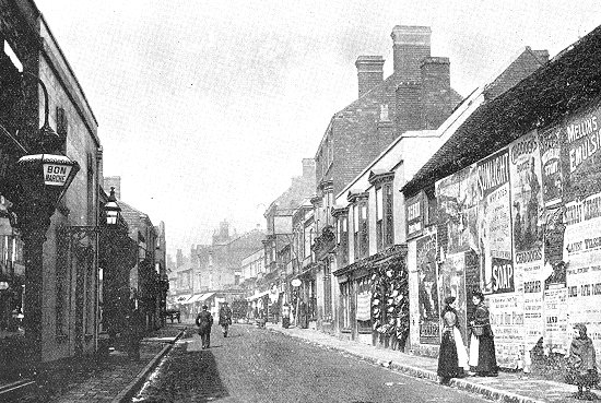
Upper High Street. |
| The tall building on the right is The Grapes Inn,
formerly The Royal Exchange Inn, and which in olden
Wednesbury was a quaint hostelry known as The Green Man
Tavern. The buildings on the left can be seen only part of
the way along because immediately beyond them the
thoroughfare is being widened. The High Street is part of
the old coaching road through Darlaston to Wolverhampton and
Salop. |
|
Holyhead Road. |
Holyhead Road is the main thoroughfare
from Birmingham to Wolverhampton. It is, in fact, the old
Roman Road from London to Holyhead.
The part seen in the picture is a diversion
from the original road, and was cut in 1821 to save the mail
coaches running through the Market Place and along the High
Street. |
| Within living memory the road wore quite a country
aspect, there being, as recently as 1830, no houses between
the Dartmouth Hotel (the building from which the flag is
flying) and the Red Lion Hotel in Bridge Street. In the
foreground of the picture is seen the boundary wall of
Brunswick House, the residence of Alderman Williams, J.P.,
and in the middle distance is the corner of Loxdale Street. |
| Bridge Street takes its name from the Bridge over the
Tame Brook, the dividing line between the parishes of
Wednesbury and West Bromwich. At one time it was a favourite
residential quarter, but the noise and the smoke of the many
works which have come into existence in that locality have
caused a great depreciation in the value of house property.
The hotel on the right is the old Red Lion, which was a well
known hostelry in the coaching days. |
Bridge Street. |
| It has recently been modernised by a firm of brewers,
and will scarcely be recognised by former inhabitants. The
three-gabled house on the left is the Coachmakers' Arms, one
of the oldest unrestored buildings in the town. |
|
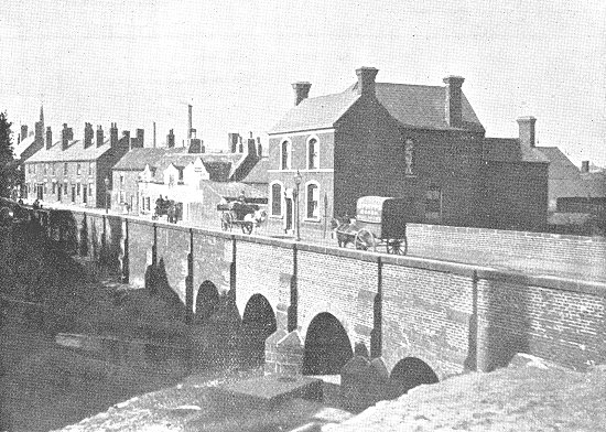
Wednesbury Bridge. |
The Bridge which spans the river Tame
at Wednesbury was erected between 1819 and 1826 by Telford,
the engineer. A few years later forty coaches a day
passed over it; for it was part of the great Holyhead Road
between London, Chester, and Wales, en route for Ireland.
The construction of the bridge was undertaken as a relief
work, the poverty of Wednesbury and other towns making
implements of war being very severe after Waterloo. |
| Previously there was a ford across the bed of the
stream, the approach to which is clearly indicated by the
low level of the old cottages on the West Bromwich side of
the Bridge. |
| A view of Wednesbury's only residential suburb, with the
Church of St. Paul, Wood Green, in the distance. On the
right part of The Limes is seen the residence of
Lieutenant-Colonel Smith, formerly occupied by Mrs. Edwin
Richards, founder of the Art Gallery, and previously by Mr.
Rooth. Below is seen a larger white house, which was the
home of the late Quaker Lloyd. |
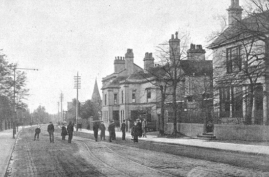
Wood Green. |
| On the right of the road are the telephone wires, and on
the left the tramway wires. The view is looking towards
Bescot, Pleck, and Walsall. Wood Green is a favourite
promenade, and on a fine Sunday evening presents a very busy
aspect. |
|
Wednesbury Brunswick Park (General
View). |
Brunswick Park was established in 1887
to celebrate the Queen's Jubilee.
It is a spot of great beauty, and is
very highly appreciated by the inhabitants, and also by
visitors, of whom it attracts large numbers.
The Park contains a large mound, from
the summit of which a pleasing and extensive view of the
surrounding country is obtained. |
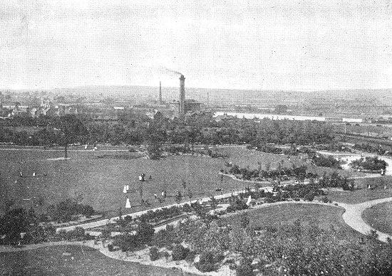
| This view is taken from the Mound, and shows a large
portion of the public pleasure ground with its bedding,
shrubberies, and ornamental water. In the middle distance is
seen the Waterworks Engine House, with Elwell's chimney
stack beyond it, and Elwell's Pool on the right. In the far
distance lie Walsall and Barr. |
| This Canal was cut in 1844 to run from Ryder's
Green back into the other side of Birmingham, through Aston, and so
relieve the traffic between Birmingham and the Black Country. Near
Wednesbury it had to be carried over Hydes Lane by an Aqueduct. The
view is from Crankhall Bridge, looking towards the valley of the
River Tame. On the right the bank consists of drift sand,
the latest of the geological formations. |
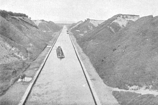
Tame Valley Canal. |
| This Bustleholme Sandbed has been boated
away in thousands of tons to all the surrounding towns of the Black
Country, where, as sharp, gritty building sand, it fetches about 9d.
a ton, or, as finer sand, for foundry purposes, a small portion of
it realises almost 5s, a ton. Gravel is also obtained here. Along
the banks of the Canal to the "High Bridges" is a pleasant walk, well
known to most Wednesbury people. |
|
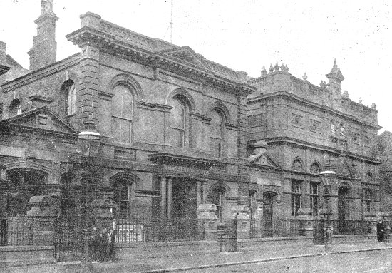
Town Hall and Art Gallery. |
These institutions form a row of public buildings of which
Wednesbury has every reason to be proud. The Town Hall was
erected in 1871, and will seat upwards of 1,000 persons.
It contains a semicircular Gallery, and an orchestra in
which is placed a handsome organ presented by Alexander
Brogden, Esq., the then member of Parliament for the
borough. |
|
The instrument cost £1,300. In the year
1891 the old approaches to the Town Hall were replaced by
handsome corridors, other important structural improvements
have been effected, and the interior and municipal offices
were decorated at a total cost of upwards of £2,000.
By means of the corridors the Town Hall
and the Art Gallery are connected, and the utility of both
buildings is considerably enhanced thereby. The Art Gallery,
opened by the then Mayor (Mr. John Hunt Thursfield), on
November 4th, 1891, is the outcome of a bequest left by Mrs.
Richards in 1885, consisting of a valuable collection of
pictures, with £2,000 towards a building to contain them,
£1,000 for the caretaker's salary, and £500 for the
re-gilding of the pictures. It is, without doubt, the most
imposing structure in the town. |
| The value of the Richards Collection at the Art Gallery,
here shown, has been estimated variously at sums ranging
from £5,000 to £10,000.
The total cost of the building was £6,000. |
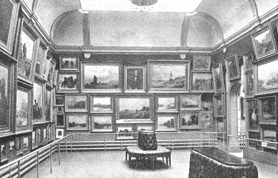
Wednesbury Art Gallery – The Richards
Collection. |
|
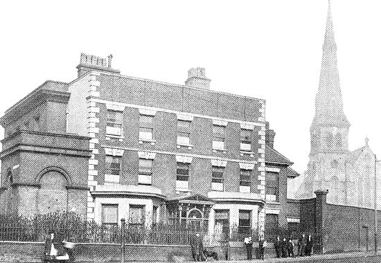
Lloyd’s Bank. |
The wing in which the bank business is conducted is
comparatively new. The residential portion, however, is old.
At the beginning of the century this house was the residence
of Edward Wright, Esq., a gentleman of independent means.
About 1830-40 it was used as Mr. Peter Turner's Private
Academy for young ladies and gentlemen. Later it became the
"Wednesbury Old Bank" of Messrs. Philip and Henry Williams.
|
|
Now it is one of the very many branches
of the great banking house established by a member of that
Lloyd family whose history is so closely connected with
Wednesbury. At one time its gardens extended beyond the
Police Station, while at the rear (where St. John's Church
stands) was a large field containing a pleasant cottage
farm. |
| The two churches which crown the hill upon which
Wednesbury is built are visible from all points of the
compass, and are the first objects which catch the eye of
the pedestrian from whichever quarter he approaches the
town.
Our view, a very effective one, is taken from the
limestone mound which rises from the Old Park Road. The
cottages in front constitute part of Hall End. |
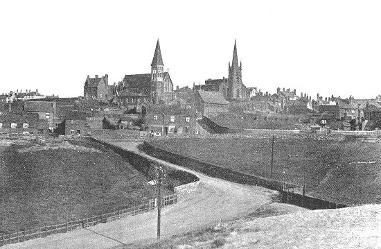
Wednesbury (looking S.E.). |
| On the right of St. Mary's is seen the Roman Catholic
schools, and on the left the presbytery. Between the two
churches the residence of the Vicar of Wednesbury is just
visible. The white house on the left of the picture is the
residence of Mr. G. S. Guy, J.P., and among the houses to
the right of the Parish Church is included the one which was
once occupied by Mr. J. Russell, founder of the Crown Tube
Works. Wednesbury natives will easily identify the situation
of the "Tommy Shop." |
|
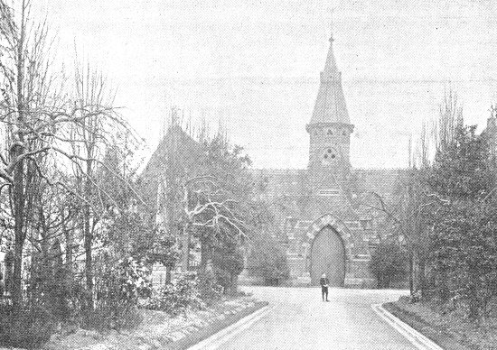
Cemetery Chapel. |
Wednesbury Cemetery, one of the prettiest in the Black
Country, and which has an area of 12½ acres available for
burials, was consecrated l0th March, 1868, when all the
school children of the town were paraded. Its total cost was
£10,000, and it was the outcome of years of agitation during
the old days of Vestry government. Under the Burial Act the
Town Council (as Local Authority) now constitutes the Burial
Board. |
| The burial ground is "the clergyman's freehold." The
Burial Board are responsible for monumental fees, but fees
on interments they do not receive. The chapels (one for the
Established Church, and one for the Free Churches)
accommodate about 80 people in each. The architect was Mr.
Samuel Horton. |
| A
mining expert has proved the antiquity of coal-getting in Wednesbury
by stating that its "Parish Church, built during the 11th century has
its foundations laid with Pockstone, or 'clay hardened by the action
of fire,' from the burning coal below, at a very shallow
depth, and which caught fire by spontaneous combustion."
|
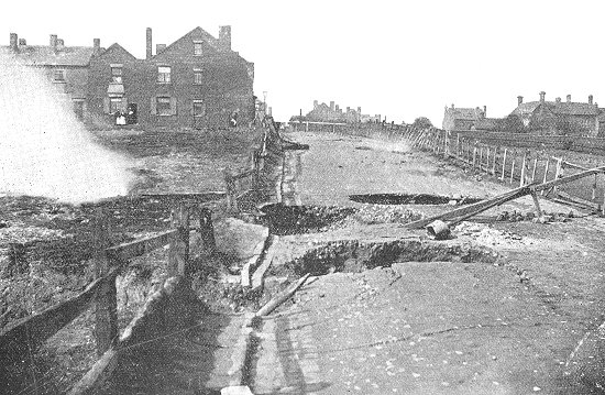
Subterranean Fire at King’s Hill. |
| The Parish Registers
bear witness to the same ever present mining danger. In 1731 they
record that a collier was "most dismally scorched and roasted to
death by the Hellish Wildfire, June ye 20th", in fact, numerous
entries attribute death to "Wildfire," or "firing of the damp." The
present fire at King's Hill was first reported in 1894 as
threatening the safety of Old Park Road. Whether it originated by
spontaneous combustion, or through colliers carelessly firing some
old workings, is a moot point. In February, 1897, the road actually
fell into holes, and all traffic had to be stopped. In April a
sensation was caused not only in this locality but throughout the
country by the tragic death of the Corporation watchman through
falling into one of the burning holes. The view shows the Black Horse
Inn on the left, and All Saints' Parsonage on the right. |
|
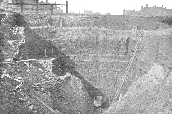
An Openwork at King’s Hill. |
This openwork is at King's Hill, immediately on the
right of the present subterranean fire. There is a deserted
openwork on the opposite side of the Old Park Road.
Hereabouts the famous ten yards seam crops out near the
surface, but somewhat thinned, and very much perished by the
percolation of storm water, and of little commercial value. |
|
Whether the perishing of the thick
coal has weakened the mine roofs and thus occasioned a vibration,
the friction from which has caused combustion to set up, will never
be known, but it is a theory which may possibly account for the underground fires
which have been known for centuries past in Wednesbury. At this
openwork an old bell pit, a century or two old, was discovered.
|
 |
|
|
|
|
|
Return to
Faces part 2 |
|
Return to
the contents |
|
Proceed to
Places part 2 |
|