Broad Street


Broad Street was formerly known as Rotten's Row which was named after the Rotten family who lived at Oxley Manor. It was later known as Lower Lichfield Street and became Canal Street after the opening of the canal. In the early 18th Century the Quakers built a meeting house and burial ground here. The open space on the corner of Westbury Street marks the site of the burial ground. During the mid 1970's many of the buildings in the lower half of the street were demolished to make way for the building of the ring road. The photographs which follow were taken during this period.
BROADST4.jpg (25732 bytes)
Almost a third of Broad Street disappeared as work on the ring road progressed.

The bottom of  Railway Street can still be seen on the left.

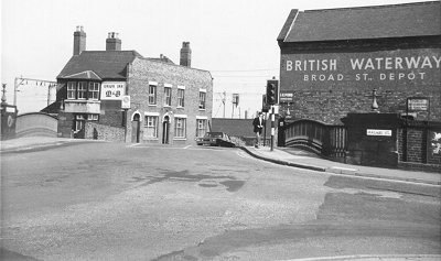
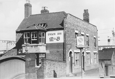
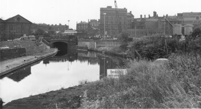
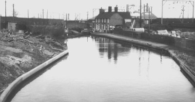
The Union Inn and old canal bridge in October 1973.

The Inn was well kept by the Bloor family and must have changed very little both internally and externally during its long life.

Mr Bloor also ran a small business from the pub repairing juke boxes. The British Waterways building on the right was originally a warehouse on the side of the Shropshire Union Wharf.

BROADST1.jpg (23923 bytes)
BROADST2.jpg (31146 bytes) The Union Inn in April 1974 just before demolition. The building to its right was the first railway station to be built in the centre of town.

It was built by the Shrewsbury & Birmingham Railway and was designed by Edward Banks. It opened on 12th November 1849 and had a single platform on top of the railway embankment which was accessed by a walkway down to the station.

It closed when the high Level station opened on 24th June 1852.

The size of the railway station can be seen from the remaining walls that were left after the first stage of demolition.

After closure it became a chapel and then served as a stables for the canal company.

In its final years it was used by Dent and Partners Limited who were builders, and Midland Painting Ltd.

BROADST3.jpg (22313 bytes)
BROADST5.jpg (33815 bytes) The view from St Peter's Church tower looking down Broad Street in June 1975. At this time the Union Inn and old railway station had finally disappeared and work was well underway on Broad Street Basin.

The old Vine Inn, now the Hoggs Head, can be seen on the corner of Broad Street. In those days buses still ran into Wulfruna Street as can be seen in the foreground.

The old canal bridge just before removal. It initially was placed in store but eventually was moved to the Black Country Museum where it is now an important feature of the black country village. BROADSTBasin3.jpg (17362 bytes)
BROADSTBasin2.jpg (20482 bytes)
Broad Street basin in June 1975. The pile of rubble on the left is all that remains of the Union Inn.

 On the right is the entrance to Victoria Basin which led to the Great Western Railway's goods depot.

The new bridge was to be built to the immediate right of the old bridge and so the canal had to be diverted.

Work on this was underway when the photograph was taken. The Chubb building in the background still had its original out-buildings at this time.

It was later to be redeveloped when the lighthouse cinema was built.

BROADSTBasin7.jpg (18098 bytes)
BROADSTBasin8.jpg (17125 bytes)
A temporary canal bridge was erected during the construction of the new bridge.

At this time the canal had been diverted and the old bridge was nearing the end of this phase of its life.

The original canal under the old bridge is now filled-in.

The canal opened in 1792 and was surveyed and engineered by James Brindley.

Much of the money for the Wolverhampton section came from the Molineux family who by then had moved into banking.

BROADSTBasin4.jpg (25791 bytes)
BROADSTBasin6.jpg (22516 bytes) The temporary canal bridge.
When the new canal bridge had been completed the old one was finally removed.

The original course of the canal can be seen from the pile of earth that now covers it.

BROADSTBasin5.jpg (15838 bytes)
Broadstbasin1.jpg (16071 bytes) Broad Street Basin from the new bridge. At this time it is still a scene of dereliction but that will soon change.

The area behind the wall on the right was the old Hay Basin. It was served from a siding off the main railway line on the embankment above, which ran down to it.


Return to
Waterloo Road
  Return to the
beginning
  Proceed to the
Civic Centre